
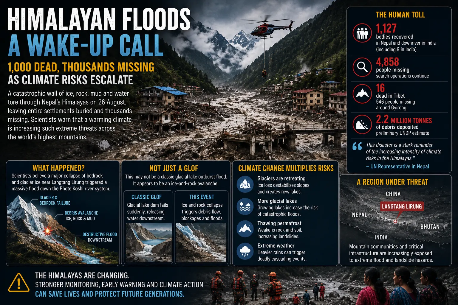
A week after a wall of ice, rock, mud and water tore through the Himalayas, the scale of the disaster is still increasing. Nepal Police said on Wednesday that 1,127 bodies had been recovered from flood-affected areas in Nepal and downstream in India, while 4,858 people remained listed as missing. Across the border in Tibet, Chinese authorities have separately reported 16 deaths and 546 people missing.
The figures make the August 26 disaster one of the deadliest Himalayan flood events in recent history. Yet the human toll tells only part of the story. Settlements were buried, roads and bridges disappeared, hydropower installations were inundated and millions of tonnes of debris moved through the Bhote Koshi and Trishuli river systems. Rescue operations remain under way in difficult terrain, including searches around damaged power projects where workers may still be trapped underground.
The catastrophe has also become a warning about a less familiar consequence of a warming climate. Scientists examining satellite imagery believe a major failure of bedrock and glacier ice near the Langtang Lirung area sent an enormous mass down the mountainside and into the river system. The precise sequence is still being reconstructed, and it would be premature to attribute the individual collapse solely to climate change. What is much clearer is that rising temperatures are transforming the Himalayan cryosphere in ways that increase several interconnected hazards: glacier retreat, unstable slopes, expanding glacial lakes, thawing frozen ground and sudden floods capable of travelling far downstream.
1,127 bodies: recovered according to Nepal Police’s latest update, including nine found downstream in India.
4,858 missing: Nepal Police says searches continue for thousands of people affected by the flood.
Tibet: Chinese authorities separately report 16 confirmed deaths and 546 people missing around Gyirong.
2.2 million tonnes: UNDP’s preliminary estimate of debris deposited within the areas it analysed.
The Disaster Began High Above the River Valleys
The flood struck on the morning of August 26 in the high-altitude border region of Rasuwa. Water levels in the Bhote Koshi system rose with exceptional speed before a destructive mixture of water, sediment, boulders, ice and other debris moved downstream through narrow Himalayan valleys. Nepal’s Ministry of Home Affairs says the flood subsequently affected riverbank communities in Rasuwa, Nuwakot, Dhading and Gorkha, with bodies later recovered much farther downstream.
Initial information produced uncertainty about exactly what had happened. Himalayan disasters can be triggered by intense rainfall, earthquakes, landslides, avalanches, glacial lake failures or combinations of several processes. The seismic signal generated by the August 26 event was sufficiently strong to be detected at regional monitoring stations, adding to early uncertainty over whether an earthquake had occurred.
Subsequent satellite analysis produced a clearer picture. Scientists examining before-and-after imagery identified a substantial collapse of bedrock beneath part of a glacier, carrying a large volume of ice and rock down the mountain. Once the material reached the valley, its enormous kinetic energy mobilised water, sediment and debris, creating a destructive flow that continued through the river network.
One hypothesis is that debris temporarily obstructed part of the river, allowing water to accumulate before breaking through and intensifying the surge. Scientists have cautioned that the event remains under investigation, however, and the complete sequence may take time to establish. That distinction matters because understanding the mechanism determines what kinds of monitoring and warning systems might reduce the consequences of similar events in future.
This Was Not Necessarily a Classic Glacial Lake Outburst Flood
The disaster is frequently discussed alongside glacial lake outburst floods, or GLOFs, but the two phenomena should not be treated as identical. A classic GLOF occurs when water accumulated in a glacier-fed lake suddenly escapes after a natural dam fails, overtops or is destabilised. The resulting surge can move enormous quantities of water and debris through mountain valleys with very little warning.
The preliminary evidence from the August 26 disaster points instead towards an ice-and-rock avalanche involving glacier and bedrock failure. Both hazards can nevertheless emerge from the same rapidly changing high-mountain environment. Glacier retreat can expose steep rock faces, while warming and permafrost degradation can reduce the stability of mountain slopes. At the same time, meltwater creates new glacial lakes and enlarges existing ones.
The result is not one new climate hazard but a chain of interconnected risks. A landslide or ice avalanche can itself cause a flood, strike a glacial lake and generate a wave, block a river and create a temporary lake, or trigger a sudden breach hours later. In steep Himalayan terrain, the transition from mountain collapse to downstream disaster can therefore occur rapidly and across great distances.
More than 5,000 people remain listed as missing when the latest separately published Nepalese and Tibetan figures are considered together.
The Flood Continued Far Beyond the Mountains Where It Started
The distribution of recovered bodies demonstrates the geographical reach of the disaster. Nepal Police’s latest figures include 45 bodies recovered in Rasuwa, 155 in Nuwakot, 59 in Dhading, 66 in Gorkha, 38 in Tanahun, 348 in Chitwan, 217 in Nawalparasi East and 190 in Nawalparasi West. Nine bodies were recovered across the border in India. The pattern shows how a high-altitude event can become a regional river disaster as water and debris move through interconnected catchments.
The destruction also crossed northwards into Tibet. Gyirong Port, one of the principal crossing points between Nepal and China, was struck by the debris flow. Chinese authorities say 16 people have been confirmed dead there and 546 remain missing. The road connecting rescuers with the core disaster area was heavily damaged, forcing teams initially to depend on aircraft and difficult approaches on foot before access for heavy machinery could be restored.
The border location adds another dimension to the crisis. Natural hazards do not follow political boundaries, and river systems originating on one side of a frontier can place communities on the other side at immediate risk. Monitoring a glacier, lake or unstable mountainside is therefore only part of the challenge; information also has to move quickly enough between national agencies for warnings to reach downstream populations.
Latest Published Disaster Indicators
| Indicator | Latest figure | Area |
|---|---|---|
| Bodies recovered | 1,127 | Nepal-led count, including 9 in India |
| People missing | 4,858 | Nepal-led search |
| Confirmed deaths | 16 | Tibet |
| People missing | 546 | Tibet |
| Debris estimated | 2.2m tonnes | UNDP analysed areas |
Source: Nepal Police, Chinese regional authorities and United Nations Development Programme, latest available updates.
Casualty and missing-person figures remain provisional. Disaster records can change substantially as people make contact with authorities, duplicate reports are removed, remains are identified and inaccessible areas are reached. The latest totals should therefore be understood as a developing operational picture rather than a final accounting of the disaster.
Hydropower Turned a Natural Disaster Into an Economic Shock
Nepal’s reliance on hydropower makes its river valleys economically valuable but also exposes expensive infrastructure to mountain hazards. UNDP’s preliminary assessment found that 11 hydropower stations and one solar facility with combined capacity of 431.1 megawatts had stopped operating after the disaster. Fifteen additional power projects under construction, with planned capacity of about 470 megawatts, were also damaged.
Several hydropower installations became focal points for the rescue operation because large numbers of workers were present when the flood arrived. Authorities have been attempting to reach underground structures where some workers may have survived because tunnels and internal rooms could contain air, water and supplies. At the Rasuwagadhi Hydroelectric Project, officials have expressed hope that dozens of workers could still be inside a protected underground area.
Bridges and roads suffered extensive losses as well. Reuters reported that 31 motorable bridges were washed away and nearly 50 suspension bridges were affected. In a mountainous country where relatively few roads connect remote communities with markets, hospitals and regional centres, the loss of a single bridge can have consequences far beyond the physical structure itself.
The rebuilding cost will therefore include much more than replacing damaged homes. Nepal must restore electricity generation, transport corridors, telecommunications, water systems and public services while simultaneously supporting displaced households and continuing the search for missing people. Initial government estimates cited in international reporting have placed reconstruction needs in the billions of dollars, although any precise total remains preliminary while damage assessments continue.
Why Hydropower Is Both Part of Nepal’s Future and Part of Its Risk
Hydropower is central to Nepal’s development strategy because the country’s steep terrain and large river systems provide substantial renewable-energy potential. Electricity exports can generate foreign earnings, expanded domestic supply can support industry, and greater electrification can reduce dependence on imported fossil fuels. The economic case for further hydropower development remains strong.
But a changing mountain environment alters the engineering assumptions on which infrastructure is built. A power station designed using historical river flows may face different risks if extreme floods become larger, glaciers retreat or sediment loads rise. Access roads, transmission lines, worker accommodation and construction sites can be vulnerable even when a dam or powerhouse itself survives.
This does not mean hydropower should be abandoned. It means the assessment of where and how projects are built increasingly has to include compound hazards originating far upstream. A glacier collapse several kilometres away may be as relevant to a power station’s safety as rainfall immediately above the project site.
That requires better hazard maps, stronger sediment management, more conservative siting of critical structures and evacuation systems designed for events that may give communities only minutes or hours to respond. In the most exposed valleys, it may also mean accepting that infrastructure cannot simply be strengthened indefinitely against every conceivable event.
The Himalayas Are Losing Ice at an Accelerating Rate
The wider scientific evidence provides the climate context for the disaster. The World Meteorological Organization reported in June that all 23 glaciers monitored across High Mountain Asia lost mass during 2025. Above-average temperatures and below-average winter snowfall contributed to the losses, continuing a long-term retreat that is already changing water systems across the region.
Research published by the International Centre for Integrated Mountain Development in 2026 found that glacier ice loss across the Hindu Kush Himalaya has accelerated substantially, with rates roughly doubling since 2000. Long-term monitoring indicates losses of up to 27 metres of ice thickness since the mid-1970s in parts of the region.
Earlier peer-reviewed ICIMOD projections show why the changes are expected to continue. Even if global warming is held below 2°C, Hindu Kush Himalayan glaciers are projected to lose roughly 30% to 50% of their present volume by 2100. Under current emissions trajectories, losses could reach as much as 80% by the end of the century.
Those projections do not mean every glacier will behave in the same way. The Hindu Kush Himalaya stretches thousands of kilometres and includes enormous variations in altitude, precipitation, temperature and glacier type. Some glaciers can temporarily advance or remain relatively stable even while regional ice mass declines. The important point is the direction and scale of the regional change.
Warming Can Make Mountains Less Stable as Well as Melt Their Glaciers
Glacier retreat is often described primarily as a water-supply problem, but the physical consequences begin before the ice has disappeared. Glaciers can help support or insulate steep mountain slopes. When ice thins and retreats, previously frozen or protected rock can become exposed to repeated freezing, thawing and warming. Permafrost within mountain rock can also degrade as temperatures rise.
These processes can contribute to instability, although geology, earthquakes, rainfall, slope geometry and local conditions remain important. A rock-and-ice avalanche therefore cannot automatically be labelled a climate-change event simply because it occurs on a retreating glacier. Establishing the contribution of warming to a particular collapse requires detailed scientific analysis.
The broader trend is better established. The Intergovernmental Panel on Climate Change has concluded with high confidence that continued glacier retreat, new glacial lakes, changing permafrost conditions and slope instability will increase several mountain hazards. The same warming that gradually removes ice over decades can therefore produce sudden events lasting only minutes.
This distinction is essential for responsible climate reporting. Climate change does not need to be the sole cause of a disaster to alter its probability or severity. Earthquakes, fragile geology and natural glacier dynamics existed in the Himalayas long before industrial warming. Climate change is modifying the environmental conditions within which those processes now operate.
Glacial Lakes Create a Second and More Widely Recognised Threat
The Himalayan region already contains thousands of glacier-fed lakes. As glaciers retreat, depressions previously occupied by ice can fill with meltwater, creating new lakes or enlarging existing ones. Many are held back not by engineered dams but by loose accumulations of rock, sediment and ice left behind by retreating glaciers.
An ICIMOD and UNDP assessment published in 2020 identified 47 potentially dangerous glacial lakes across the Koshi, Gandaki and Karnali river basins spanning Nepal, China and India. Twenty-one were in Nepal, 25 in China and one in India. Researchers have since indicated that the real number of potentially hazardous lakes is likely to be higher as the mountain environment continues to change.
Those 47 lakes should not be interpreted as a list predicting the August 26 disaster. The current event appears to have been initiated by a glacier-and-bedrock collapse rather than the straightforward failure of one of the catalogued lake dams. The value of the inventory lies elsewhere: it demonstrates how many separate high-altitude hazards already require observation across borders and how quickly that monitoring challenge is expanding.
The Number of People Exposed Runs Into the Millions
The immediate disaster affected a relatively narrow set of Himalayan valleys, but the larger risk extends throughout one of Asia’s most important water-producing regions. The Hindu Kush Himalaya supplies water to river systems serving almost two billion people across mountain and downstream areas. The Ganges, Brahmaputra, Indus, Mekong and other major rivers are connected to snow and ice stored in these mountains.
A senior UN official warned after the Nepal disaster that populations exposed to glacial flood hazards across the region run into the millions. Exposure is particularly difficult to reduce because many settlements, farms, roads and hydropower projects have developed along rivers where water, transport access and relatively flat land are available. Moving entire communities uphill or away from valleys is economically and socially difficult.
Mountain poverty can reinforce the problem. Wealthier communities may be able to relocate houses, insure property, reinforce infrastructure or invest in alternative transport links. Families dependent on a small plot of agricultural land, tourism or a job at a hydropower project may have far fewer choices. Climate risk therefore interacts with income, geography and access to public investment rather than affecting every household equally.
Early Warning Systems Can Save Lives, but They Cannot Stop the Mountain
Technology is an important part of the response. Satellites can track glacier retreat and identify expanding lakes. Ground instruments can monitor water levels, unstable slopes and seismic movement. Automated river gauges can detect sudden increases in flow, while mobile networks and sirens can transmit warnings to downstream settlements.
For some glacial lakes, direct engineering is possible. Authorities can lower water levels, strengthen drainage channels or reduce pressure on unstable natural dams. Nepal has already undertaken such work at several high-risk lakes, and new adaptation programmes are extending monitoring and early-warning systems to other basins.
But the August disaster illustrates the limits of engineering. A gigantic rock-and-ice avalanche can develop with much less warning than the gradual filling of a lake. Sensors themselves can be destroyed, communications can fail and the first communities downstream may have only a very short time to evacuate. No economically realistic structure can be designed to stop every conceivable volume of rock, ice and water descending through a narrow mountain valley.
The objective is therefore not to eliminate all risk. It is to reduce exposure and prevent a natural event from becoming a catastrophe wherever possible. That requires several layers of defence: monitoring the hazard, communicating warnings, keeping critical facilities away from the highest-risk zones, preparing evacuation routes and making sure communities know what to do when an alarm arrives.
How a Changing Cryosphere Creates Different Hazards
| Change | Possible hazard | Potential response |
|---|---|---|
| Glacier retreat | New or larger lakes | Satellite monitoring and lake management |
| Permafrost thaw | Rock and slope failure | Hazard mapping and restricted development |
| Ice-rock avalanche | Sudden debris flood | Detection and rapid evacuation |
| Lake-dam failure | Glacial lake outburst flood | Early warning and controlled drainage |
Source: IPCC, ICIMOD, UNDP and World Meteorological Organization assessments.
Cross-Border Data May Become as Important as Cross-Border Rescue
The Himalayas present a particular governance problem because the hazard may originate in one country while the consequences arrive in another. A glacier or lake in Tibet can threaten communities in Nepal or India. An avalanche beginning in Nepal can strike infrastructure in Tibet and send floodwater into lower river systems. Warning time can be lost if data are collected nationally but not transmitted regionally.
The case for greater cooperation therefore extends beyond emergency assistance after a disaster. Countries need shared satellite information, common hazard classifications, river-level data, compatible warning systems and agreed protocols for rapidly alerting communities across borders. The value of such cooperation grows as the number and size of glacial lakes change faster than static hazard maps can be updated.
Political differences complicate this work. The Hindu Kush Himalaya crosses some of Asia’s most sensitive borders, while water itself is economically and strategically important. Yet the physics of a flood makes cooperation difficult to avoid. A downstream warning is useful only if it arrives before the water does.
Reconstruction Will Have to Account for the Climate of the Future
The immediate priority in Nepal remains search, rescue, identification of victims and support for displaced communities. Reconstruction will follow, but rebuilding exactly what existed before August 26 would risk restoring the same vulnerabilities. Roads, bridges, power projects and settlements will need to be assessed against hazards that may look different during their future operating lives than they did when the original structures were designed.
This creates difficult choices. Moving infrastructure to safer ground can be expensive or physically impossible in narrow valleys. Building stronger bridges and power facilities increases initial costs. Relocating communities can disrupt livelihoods and social networks. In some cases, governments may conclude that protecting an existing settlement is feasible; in others, the long-term risk may become too high.
Climate adaptation therefore involves economic decisions as well as engineering. Governments have to decide where limited public money prevents the greatest expected loss of life and infrastructure. Insurance, disaster funds and international climate finance become relevant because countries such as Nepal face adaptation costs that can be large relative to their national budgets.
The rebuilding challenge is especially significant for hydropower. Projects expected to operate for several decades need to incorporate not merely today’s glacier positions and river conditions but plausible future changes in upstream hazards. Climate resilience becomes part of financial viability because a plant that produces inexpensive electricity but repeatedly loses access roads, transmission lines or turbines to extreme floods may ultimately prove much more costly than expected.
The Risk May Rise Before Glacier Water Eventually Declines
The long-term Himalayan water story contains an apparent contradiction. Accelerated melting can initially increase the amount of water moving from glaciers into rivers and lakes. Later in the century, as the total volume of glacier ice becomes smaller, the amount of stored frozen water available to melt can decline. ICIMOD expects water availability from parts of the Hindu Kush Himalaya to reach a peak around mid-century before decreasing in many glacier-dependent systems.
That transition creates different risks at different times. In the nearer term, expanding lakes, destabilising slopes and larger meltwater volumes can increase certain flood and landslide hazards. Over longer periods, declining glacier storage can create greater seasonal water insecurity for communities and economies dependent on predictable meltwater.
The region therefore faces both too much water and too little, depending on location, season and timeframe. Adaptation designed solely around flood protection would miss the later challenge of water scarcity. Likewise, policies focused only on long-term glacier loss could underestimate the immediate danger of unstable mountain terrain.
What Can Be Said About Climate Change — and What Cannot Yet Be Said
The disaster has inevitably prompted descriptions of a climate catastrophe. The scientific evidence supports a strong connection between global warming and the transformation of the Himalayan cryosphere, but responsible attribution requires precision. No completed event-attribution study has yet established how much human-caused warming altered the probability of this specific August 26 glacier and bedrock collapse.
There are several other relevant factors. The Himalayas are geologically young and naturally unstable. Earthquakes are common. Monsoon rainfall can saturate slopes, while erosion constantly reshapes valleys. Glacier movement itself can produce collapses even in the absence of long-term climate change.
At the same time, the background conditions are clearly changing. Temperatures are rising, glaciers are losing mass at accelerating rates, permafrost is degrading and glacial lakes are expanding. The IPCC assesses increases in several associated high-mountain hazards with high confidence. Climate change is therefore not an alternative explanation competing with geology; it is increasingly modifying the geological and hydrological environment in which those natural processes occur.
The Warning Extends Far Beyond Nepal
Similar hazards exist across the Himalayas and other high mountain systems. India, Pakistan, Bhutan and China have all experienced destructive glacial or high-altitude flood events in recent years. Because mountain ice is retreating globally, comparable risks are also being studied in the Andes, European Alps, Alaska and other glacierised regions.
The Hindu Kush Himalaya is exceptional because of the number of people dependent on its rivers and the rapid development taking place in its valleys. Roads, dams, tourism infrastructure, towns and electricity projects are expanding at the same time as the physical environment is changing. Economic development can reduce vulnerability by providing stronger infrastructure and emergency services, but it can also place more valuable assets and more people in exposed locations.
The central policy challenge is therefore not simply to stop building in mountain regions. It is to determine where development remains acceptable, what level of protection is reasonable and which locations should be treated as too dangerous for certain forms of permanent infrastructure.
The Next Himalayan Disaster Does Not Have to Produce the Same Human Toll
The August 26 flood cannot be reversed, and some hazards of its magnitude may overwhelm even sophisticated defences. But the consequences of future events are not predetermined. Earlier detection, clearer risk maps, stronger communications, safer infrastructure and rapid evacuation can determine whether a sudden flood kills hundreds of people or reaches largely empty danger zones.
The most important decisions will often be made years before an emergency. A hydropower station built outside a debris corridor does not need to be evacuated from it. A bridge designed for extreme sediment loads is less likely to disappear. A village with a working warning system does not have to wait until residents can see the flood approaching. Regional data sharing can give communities additional minutes or hours that no emergency response can create after the event has begun.
There is also a global dimension that local adaptation cannot solve. The future scale of glacier loss depends on how far global temperatures rise. Even strong emissions reductions cannot restore ice already lost or remove the near-term hazards created by existing warming, but lower future warming can substantially reduce the amount of glacier loss expected by the end of the century.
The catastrophe in Nepal is therefore neither proof that every Himalayan valley will become uninhabitable nor an isolated accident with no wider significance. It is evidence of what can happen when extreme topography, vulnerable infrastructure and a rapidly changing cryosphere intersect. With more than 1,100 bodies already recovered and thousands of people still missing, the lesson is arriving at an extraordinary human cost: the Himalayas are changing faster than the systems built around them, and future safety will depend on adapting before the next mountain gives way.
Sources
Nepal Police — Bhotekoshi Flood Update, 2 September 2026
Government of Nepal, Ministry of Home Affairs — Official Disaster Relief Appeal
Reuters — Nepal Flood Rescue and Recovery Update, 2 September 2026
Reuters — Himalayas Face Severe Glacial Flood Risks in Years Ahead, UN Official Warns
Xinhua — Latest Relief and Rescue Progress at Gyirong Border Port
United Nations Development Programme — Nepal Floods and Preliminary Debris Assessment
ICIMOD — Major Flash Flood in Nepal’s Rasuwa District
Associated Press — Satellite Analysis of the Nepal-Tibet Glacier and Bedrock Collapse
ICIMOD — Hindu Kush Himalaya Glacier Loss Assessment, 2026
ICIMOD — Water, Ice, Society and Ecosystems in the Hindu Kush Himalaya
World Meteorological Organization — State of the Climate in Asia 2025
Source & Transparency
This article is published by Ireland Newspaper for editorial and informational purposes.
Published: 2 September 2026 · Updated: 2 September 2026

Newsroom Ireland Newspaper
Ireland Newspaper editorial team prepares daily news coverage for readers in Ireland and abroad.