Before the Castles: West Cork in the Twelfth Century
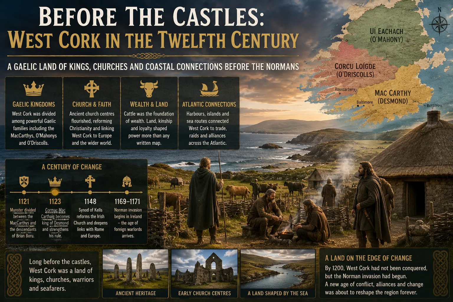
Long before the tower houses, walled towns and ruined abbeys that now dominate West Cork’s medieval landscape, the region was part of a complex Gaelic world of rival dynasties, ancient church centres, cattle wealth and Atlantic connections. During the twelfth century, the rise of the MacCarthy kings of Desmond, the continuing strength of families associated with the O’Mahonys and O’Driscolls, major reforms within the Irish Church and the arrival of Anglo-Norman power transformed the political landscape. By 1200, West Cork had not been conquered, but it had entered a new and far more dangerous age.
Stand today on the coast near Mizen Head, look across the islands around Baltimore or follow the road through Rosscarbery towards Bantry, and medieval West Cork seems to announce itself through stone. Ruined castles, old churches and later monastic sites appear across the landscape. Yet a traveller somehow transported back to the year 1150 would find a very different country. Many of the stone tower houses now associated with the great West Cork families did not yet exist. The political entities familiar from later medieval history had not all been formed, and even the expression “West Cork” would have meant nothing to the people who lived there.
Instead, they inhabited a landscape divided among Gaelic territories whose boundaries reflected kinship, lordship, geography and military power rather than the modern administrative map of County Cork. The twelfth century would become one of the decisive periods in that landscape’s history: a century that began with struggles between Irish dynasties and ended with Anglo-Norman armies probing deep into the south-west.
West Cork Did Not Yet Exist
To understand the twelfth century, the first modern assumption that has to be discarded is the idea of County Cork as a single political unit. Medieval people did not think of themselves as residents of a county stretching from Youghal to Mizen Head. The county system belonged to a later phase of English administration. The south-west was instead made up of territories associated with different peoples and ruling families, and their frontiers could move as political fortunes changed.
Among the most important indigenous groupings were the Corcu Loígde, whose territory was strongly associated with the area that later formed the medieval diocese of Ross. Their ruling families included the ancestors of the O’Driscolls, whose name would later become inseparable from the maritime history of Baltimore, Cape Clear and Castlehaven. Historical and genealogical traditions place Corcu Loígde territory across a substantial part of what is now south-west Cork, with Rosscarbery occupying an important position within that world.
Another major political force was the Uí Eachach, associated in later centuries particularly with the O’Mahony family. Their influence extended across large parts of southern Cork and towards the western peninsulas. During the twelfth century, they remained an important regional power in areas that would later become central to the history of Mizen, Bantry and the south-western coast.
It is important not to project later medieval political structures backwards. Anyone familiar with West Cork castles may instinctively think of the MacCarthy Reaghs as the region’s great medieval rulers. They certainly became so, but the MacCarthy lordship of Carbery developed mainly during the thirteenth century and later. In the year 1150, the political map that later became associated with Carbery had not yet fully taken shape.
The Rise of Desmond
Above these local territories stood a much larger struggle over southern Munster. The early twelfth century was dominated by competition between the Uí Briain dynasty and the rising MacCarthy family. Munster was repeatedly invaded, divided and reorganised as powerful rulers attempted to impose supremacy over competing kingdoms.
In 1121, Toirdelbach Ua Conchobair, king of Connacht and one of the most powerful rulers in Ireland, intervened in Munster and divided the province between the MacCarthys and the descendants of Brian Boru. Two years later, Donnchad Mac Carthaig died as king of Desmond and his brother Cormac succeeded him.
Desmond derives from Deasmhumhain, meaning South Munster. It was much larger than modern West Cork, but the political fortunes of its kings increasingly mattered to the south-west. The MacCarthys were building a royal power that would eventually become one of the dominant forces in Cork and Kerry, although their authority over individual territories was never as simple as colouring a modern map with one family’s name. Local dynasties retained their own lands, alliances and military strength.
The politics of the period could be brutal. Hostages were taken to guarantee agreements, cattle and property were seized during military campaigns, rivals were imprisoned or killed, and kings could lose power almost as quickly as they gained it. Authority depended not only on inheritance but on alliances, military success and the ability to hold the loyalty of subordinate rulers.
Cormac Mac Carthaig and an Ambitious Gaelic Kingdom
Cormac Mac Carthaig was one of the outstanding figures of twelfth-century Munster. His importance to West Cork lies less in any claim that he personally ruled every valley and peninsula than in what his career reveals about the political world into which the region was integrated.
Cormac participated at the highest level of Irish politics and sponsored one of the most sophisticated buildings created in twelfth-century Ireland. Between 1127 and 1134 he constructed the chapel that still bears his name at the Rock of Cashel. Although Cashel lies far from West Cork, Cormac’s Chapel demonstrates the resources, ambition and European cultural connections of the MacCarthy kings of Desmond.
That matters when imagining West Cork in the same period. Twelfth-century Gaelic Ireland was not culturally sealed off from Europe. Royal patronage, church reform, monastic networks and intellectual connections linked southern Ireland with wider European developments. The political landscape remained overwhelmingly Gaelic, but the religious and cultural world was becoming increasingly international.
Cormac’s career ended violently when he was killed in 1138 amid continued rivalry for control of Munster. His death did not end MacCarthy power, but it illustrates how unstable kingship could be. Authority depended on the ability to survive rival dynasties, internal family competition and the ambitions of more powerful kings.
Rosscarbery: A West Cork Window Onto Medieval Europe
If one place demonstrates that West Cork was connected to a wider medieval world, it is Rosscarbery. Its importance long pre-dated the twelfth century. The area was associated with the ecclesiastical tradition of St Fachtna and with Corcu Loígde territory, but during the twelfth-century reorganisation of the Irish Church, Ross developed increasing significance as a diocesan centre.
The Irish Church was undergoing major reform. Older monastic structures were being reshaped into a diocesan system more closely aligned with the organisation of the wider Western Church. Ross emerged during this process as an important ecclesiastical centre, and by the later twelfth century bishops associated with the area were appearing in the historical record.
Even more striking were the wider European connections associated with religious life in Rosscarbery. The town had links with the Irish Benedictine monastic movement on the European continent, particularly in southern Germany. The precise details and dating of every connection remain subjects for specialist historical study, but the broader picture is clear: religious communities in south-west Ireland were participating in networks that stretched far beyond the island.
The implication is significant. A person living near Rosscarbery in the twelfth century inhabited a remote Atlantic landscape by modern geographical standards, but not necessarily an isolated intellectual or religious one. Clerics, manuscripts, ideas and institutional relationships could travel enormous distances.
West Cork stood at Europe’s western edge, but it was still part of Europe.
The Coast Was a Highway, Not a Boundary
Modern maps can encourage another misconception: that Ireland’s Atlantic coast represented the end of the medieval world. In reality, the sea often connected communities more efficiently than difficult overland routes.
The great inlets of West Cork — Bantry Bay, Dunmanus Bay, Roaringwater Bay, Baltimore Harbour, Castlehaven and the smaller estuaries along the south coast — offered natural maritime corridors. Islands such as Cape Clear and Sherkin formed part of inhabited coastal territories rather than lying beyond them.
Irish rulers regularly used fleets in warfare. Naval forces could move troops, attack coastal settlements and support armies advancing overland. That wider pattern was especially relevant in the south-west, where the coastline itself created a communications network.
For communities living along the coast, the Atlantic was therefore not simply a barrier. It provided fishing grounds, routes between settlements and access to other parts of Ireland and beyond. The same coastline that today defines the tourism identity of West Cork helped shape the political and economic life of the medieval region.
1169 Changed Ireland — but West Cork Did Not Fall Overnight
The great political rupture of the century began far from West Cork. From 1169, Anglo-Norman forces entered Ireland in support of the deposed Leinster king Diarmait Mac Murchada. Their initial military successes in the east and south-east transformed the balance of power on the island.
In 1171, King Henry II of England came to Ireland in person. Diarmait Mac Carthaig, king of Desmond, submitted to him. It would be easy to interpret that act as the moment when Cork became English territory, but medieval political reality was far more complicated.
Submission to a king did not automatically result in military occupation of every territory claimed by that ruler. Gaelic kings could make political submissions for immediate strategic reasons while continuing to exercise substantial local authority. The difference between a royal claim and effective control on the ground became particularly important in Cork.
In 1177, Henry II granted what his government described as the kingdom of Cork to the Anglo-Norman adventurers Robert FitzStephen and Miles de Cogan. The grant was extraordinarily ambitious. It treated a vast existing Gaelic political landscape as territory that could be allocated by the English crown to incoming lords.
Anglo-Norman forces established themselves in and around Cork and began building territorial lordships. Yet the grant and the conquest were not the same thing. Actual occupation remained much more limited than the territory claimed on parchment, particularly as power moved westward.
For West Cork, this is one of the defining facts of the late twelfth century. The English crown could claim the region before Anglo-Norman settlers could control it.
A Frontier Begins to Move West
Pressure nevertheless increased. Anglo-Norman settlement around Cork introduced a new military, political and economic force that neighbouring Gaelic rulers could not ignore. Fortified settlements, feudal landholding and incoming families began reshaping parts of the wider Cork region, while native rulers resisted, negotiated or temporarily cooperated according to circumstances.
Diarmait Mac Carthaig survived the first phase but was killed in 1185. His son Domnall Mór Mac Carthaig succeeded him as king of Desmond and became an energetic opponent of Anglo-Norman expansion.
The struggle soon reached territory recognisable as modern West Cork. In 1190, a raiding force reached Durrus near the head of the Mizen Peninsula and carried away substantial booty. Domnall Mac Carthaig and the forces of Desmond pursued them, defeated them and recovered the plunder. Medieval annals describe heavy casualties among the invaders, although exact numbers in such accounts should always be treated cautiously.
For anyone familiar with Durrus today, the event creates a remarkable connection across more than eight centuries. The peaceful village near Bantry Bay once stood close to an active frontier between expanding Anglo-Norman power and the rulers of Gaelic Desmond.
What Did Ordinary Life Look Like?
The annals concentrate on kings, battles, deaths and raids because those were the events medieval chroniclers considered worthy of recording. Most people in West Cork, however, did not spend their lives participating directly in royal politics.
They farmed, raised livestock, maintained households, fished, travelled to churches and local gatherings and participated in networks of obligation linking families to local lords. Cattle were particularly important as a form of wealth, and livestock raiding was therefore both an economic and military weapon. Taking cattle weakened an opponent while rewarding the victors.
Political authority was also much more personal than in a modern state. There was no central bureaucracy administering West Cork from a county headquarters. Power flowed through families, kings, subordinate lords, church institutions and personal relationships. Hostages could guarantee agreements, marriage could cement alliances and military followings could determine whether a ruler retained authority.
Geography mattered enormously. Mountains and peninsulas made overland movement difficult, while rivers, bays and estuaries created natural routes. The political map was shaped as much by the landscape as by dynastic ambition.
The West Cork Castles Came Later
One of the most important lessons for anyone interested in West Cork heritage is that the dramatic castles now associated with families such as the O’Driscolls, O’Mahonys and MacCarthys should not automatically be imagined as part of twelfth-century life.
Much of the familiar tower-house landscape belongs to later centuries. The MacCarthy principality of Carbery developed principally during the thirteenth century and after, while many of the stone fortifications now regarded as symbols of medieval West Cork were constructed significantly later.
The twelfth-century landscape was instead one of transition. Older Gaelic political and ecclesiastical structures remained powerful, but the Church was being reorganised and Anglo-Norman settlement was beginning to push westwards. The spectacular castles of later medieval West Cork emerged partly from the political world created by those struggles.
The absence of large numbers of surviving twelfth-century fortresses should therefore not be mistaken for an absence of history. Much of the century’s legacy survives in territorial traditions, church centres, family histories and the political geography on which later lordships were built.
The O’Driscolls and O’Mahonys Were Already Part of an Older World
The great family names later associated with West Cork did not suddenly appear when their castles were constructed. The lineages behind the O’Driscolls and O’Mahonys were rooted in much older territorial societies.
The O’Driscolls emerged from the Corcu Loígde tradition, whose territory was strongly connected with Rosscarbery and the south-western coast. The O’Mahonys were associated with Uí Eachach, whose influence across southern Cork was already significant before the Anglo-Norman arrival.
During the twelfth century, these regional powers existed alongside the growing MacCarthy kingship of Desmond. Their relationships could involve hierarchy, rivalry, alliance and shifting territorial influence rather than straightforward subordination.
Medieval lordship was layered. A king could claim superiority over a region without eliminating the families that exercised authority locally. This helps explain why later West Cork developed such a dense mosaic of powerful Gaelic lordships. The political landscape of the thirteenth, fourteenth and fifteenth centuries had deep roots in much older structures.
By 1200, Everything Had Changed — and Much Had Not
At the beginning of the twelfth century, the region we now call West Cork belonged entirely to a Gaelic political world. Native dynasties controlled its territories, older Irish church traditions remained deeply influential and the MacCarthys were still fighting to establish their position among the great rulers of Munster.
By the end of the century, the situation was profoundly different. The MacCarthy kings had strengthened their association with Desmond, Rosscarbery had become increasingly important within the reorganised Church, and Anglo-Norman settlers had established themselves in the wider Cork region. Henry II had claimed authority over the south, and royal grants had attempted to transfer vast territories to incoming lords.
Yet West Cork itself remained difficult to conquer. The fighting around Durrus demonstrates the limits of Anglo-Norman power in the far south-west. A royal grant issued far away could declare ownership, but mountains, bays, local armies and deeply rooted Gaelic dynasties determined what happened on the ground.
That tension between claimed power and actual control would shape the region for centuries.
The Century That Made Medieval West Cork
The twelfth century is less visible in West Cork than the centuries that followed it. There are no endless lines of surviving twelfth-century tower houses to guide the visitor, and many of the territorial structures familiar from later history had not yet reached their final form. But that makes the period more important rather than less.
It was the century in which Desmond emerged as a major MacCarthy political power while older regional dynasties continued to control much of the south-west. It was the century in which church reform reorganised ecclesiastical authority and Rosscarbery strengthened its place within the religious geography of Ireland. It was also a period in which southern Irish rulers and church communities remained connected to a much wider European world.
Then came the Anglo-Normans. Their arrival after 1169 altered the political rules of Ireland. Henry II’s intervention and the grants that followed introduced a new form of lordship backed by an English monarchy and a feudal military system, yet the far west resisted easy incorporation. By 1190, warfare had reached Durrus, but large parts of West Cork remained firmly within Gaelic political control.
The West Cork that later produced the maritime O’Driscoll lordships, the O’Mahony territories of the western peninsulas and the powerful MacCarthy Reaghs of Carbery was still taking shape.
Its medieval history did not begin with the castles whose ruins survive today. It began earlier, in a landscape of kings without counties, territories without modern borders, church centres linked to continental Europe and coastal communities looking out across the Atlantic not towards the end of the known world, but towards one of its great highways.
To understand West Cork in the twelfth century is therefore to see the region at the moment before its familiar medieval identity fully emerged — still overwhelmingly Gaelic, increasingly connected to a changing Europe, and already confronting the political forces that would reshape Ireland for generations.
Source & Transparency
This article is published by Ireland Newspaper for editorial and informational purposes.
Published: 13 August 2026 · Updated: 13 August 2026

Newsroom Ireland Newspaper
Ireland Newspaper editorial team prepares daily news coverage for readers in Ireland and abroad.