
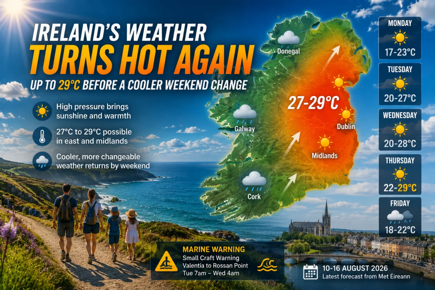
Ireland’s Weather Turns Hot Again: Up to 29°C Before a Cooler Weekend Change
High pressure is giving Ireland a largely dry start to the week, but temperatures are set to rise sharply from Tuesday. Leinster and the Midlands could reach 27°C to 29°C by midweek, while western counties face more cloud and occasional rain before cooler, more typical August weather returns towards the weekend.
Ireland is about to move through another distinctly summery spell.
After an exceptionally dry and sunny July, the new week begins quietly: light winds, plenty of dry weather and temperatures that are pleasant rather than exceptional.
That changes quickly.
Met Éireann’s national forecast issued at 10:30am on Monday, 10 August, indicates that warmer air will move across the country from Tuesday, bringing temperatures into the mid-20s widely and potentially close to 29°C in parts of Leinster by Thursday.
The heat will not be distributed evenly.
Eastern and central Ireland are likely to receive the highest temperatures and best sunshine, while Atlantic counties should see more cloud, occasional drizzle and later some heavier showers.
By Friday and Saturday, temperatures are expected to fall back towards more typical August levels.
The coming days therefore offer a familiar Irish weather contrast: summer heat in Dublin and the Midlands, Atlantic moisture in the west, and a cooler change arriving before the weekend is over.
Monday: A Quiet Start to the Week
Monday should be one of the easiest days of the week for outdoor plans.
Met Éireann expects dry conditions with sunny spells, although some hazy cloud will develop at times.
Afternoon temperatures are forecast to reach 17°C to 23°C, with the warmest conditions in Munster and Leinster. Winds should remain light and variable.
Dublin is expected to reach around 19°C, Cork about 19°C, Galway around 21°C, Donegal approximately 20°C and Limerick as high as 23°C.
Monday night remains generally dry with clear intervals.
Temperatures will fall to between 9°C and 14°C, although a little drizzle or light rain may reach parts of the southwest towards Tuesday morning.
As of Monday morning, Met Éireann had no weather, marine or environmental warnings in operation for Ireland.
Tuesday: Temperatures Climb Rapidly
Tuesday marks the beginning of the warmer spell.
Most areas should remain dry and receive good periods of sunshine.
Western counties will be cloudier, however, with some light rain or drizzle possible.
National temperatures are forecast between 20°C and 27°C, with the highest readings expected through the east and Midlands. Winds will become light to moderate from the south or southeast.
Dublin could climb to around 26°C, while Limerick may reach approximately 25°C and Donegal around 25°C.
Galway is forecast near 24°C.
Cork should be slightly cooler at approximately 21°C, reflecting the stronger maritime influence around the southern coast.
The change will be particularly noticeable compared with Monday.
In Dublin, for example, the forecast maximum rises from about 19°C on Monday to 26°C on Tuesday.
That is a seven-degree increase within 24 hours.
Tuesday Night Will Be Warm and Muggy
The warmer air will become especially obvious after sunset.
Met Éireann expects Tuesday night to remain mild and increasingly humid, with temperatures falling only to around 15°C to 18°C.
Scattered showers are also expected to move northwards across the country from the south.
Those overnight temperatures are relatively high for Ireland.
Instead of the cool nights often associated with Irish summer weather, many homes may remain noticeably warm well into Wednesday morning.
For people camping or staying in caravans, the night should therefore feel considerably milder than Monday night.
A Marine Warning Takes Effect on Tuesday
Although there are currently no general land-based weather warnings for Tuesday, conditions will become more challenging offshore.
Met Éireann has issued a Small Craft Warning from Valentia to Slyne Head to Rossan Point.
Southerly winds are expected to reach Force 6 at times from 7am Tuesday until 4am Wednesday.
That will be particularly relevant to small boats operating along parts of the west coast.
Anyone planning fishing, kayaking, sailing or other coastal activities should therefore check the latest marine forecast before leaving harbour.
Conditions on land can appear pleasant while exposed waters become considerably more difficult.
Wednesday: Warm or Hot Across Much of Ireland
Wednesday is forecast to be one of the warmest days of the week.
Eastern and southeastern counties should receive periods of sunshine, although a few showers remain possible.
Further west and northwest, there will be more cloud with outbreaks of rain.
Despite the rain risk, temperatures will remain high.
Met Éireann expects national maxima of 20°C to 28°C, with the highest values likely in north Leinster.
Dublin could reach around 27°C.
Limerick may reach approximately 26°C, while Cork and Galway are forecast around 23°C.
Donegal should also remain warm at approximately 23°C despite greater cloud cover and the possibility of a shower.
That creates a significant east-west contrast.
A traveller in Dublin could experience hot, increasingly summery conditions while somebody travelling through western counties may encounter cloudy skies and intermittent rain at roughly the same time.
Thursday Could Be the Hottest Day
Thursday currently looks like the peak of the warm spell.
Met Éireann expects another warm or hot day with sunny intervals and temperatures of 20°C to 28°C or possibly 29°C.
Leinster is again expected to be hottest.
The regional forecasts illustrate the difference.
Dublin is currently projected to reach around 27°C.
Cork may reach 24°C.
Limerick approximately 24°C.
Donegal around 23°C.
Galway should reach roughly 22°C.
The west and northwest will again have the greatest shower risk, and some of those showers may become heavy.
The east should generally receive the better sunshine and highest temperatures.
For families considering a beach day, outdoor event or long walk, Tuesday through Thursday currently offers the strongest opportunity for sustained warmth, particularly in the east.
Dublin and the East Will Have the Strongest Heat
The forecast pattern has a clear geographical explanation.
With southerly to southeasterly winds developing, eastern and inland counties will be less directly influenced by the cooler Atlantic.
That allows temperatures to rise more easily.
Dublin is forecast at approximately 26°C on Tuesday and 27°C on both Wednesday and Thursday.
The Midlands could be just as warm or even warmer, with Met Éireann’s national forecast allowing for values approaching 28°C to 29°C during the middle of the week.
Coastal locations can remain cooler because sea temperatures moderate the air immediately beside the coast.
That means somebody travelling only a relatively short distance inland can occasionally experience a noticeable increase in temperature.
West Cork and the Southwest Will Still Be Warm — but Cloudier
The picture is more complicated around Cork and the southwest.
Tuesday should remain pleasant, but western districts are likely to see additional cloud and occasional drizzle.
Cork is forecast to reach about 21°C on Tuesday before increasing to around 23°C on Wednesday and 24°C on Thursday.
Thursday also carries a greater risk of showers.
For visitors travelling around West Cork, Bantry, Beara or Sheep’s Head, this does not currently look like a washout.
There should still be substantial dry periods and warm conditions.
But the probability of cloud or a passing shower is higher than further east.
That is classic Atlantic-coast weather: warm air over the country does not necessarily mean uninterrupted sunshine along the western seaboard.
Galway and the West Could See Rain Earlier
Galway’s warmest day may arrive on Tuesday, when temperatures are currently forecast around 24°C.
Wednesday should remain warm at about 23°C but brings a greater chance of showers.
Thursday is forecast around 22°C with showers possible during the morning.
The west therefore appears likely to experience the warm spell differently from Dublin or the Midlands.
Humidity and relatively high temperatures will still be noticeable.
The difference is the cloud and rainfall.
By Friday, temperatures around Galway are forecast to drop to approximately 19°C.
That will make the change towards more typical Atlantic weather particularly obvious.
Donegal: Warm First, Then Cooler Quickly
Donegal is also expected to become unusually warm on Tuesday.
Temperatures could reach 25°C, followed by around 23°C on Wednesday and Thursday.
Cloud will be more persistent than in the east, however, and showers are possible from Wednesday onwards.
Friday brings the more obvious change.
The forecast maximum falls to approximately 18°C, compared with 25°C only three days earlier.
By Saturday and Sunday, highs may remain around 17°C to 18°C, accompanied by cloud and periods of rain.
For the northwest, the midweek burst of warmth therefore appears likely to be relatively brief.
Friday Brings the Change
The hotter air is not expected to remain over Ireland indefinitely.
Met Éireann’s current outlook points towards a cooler and generally more settled end to the working week, with temperatures returning closer to the seasonal average.
City-level forecasts show the decline clearly.
Dublin falls from around 27°C on Thursday to approximately 21°C on Friday.
Cork drops from 24°C to 21°C.
Limerick from 24°C to 20°C.
Galway from 22°C to 19°C.
Donegal from 23°C to around 18°C.
That is not cold weather.
It is simply a return towards the kind of temperatures normally associated with an Irish August.
Saturday Looks Cooler but Still Usable
Met Éireann’s national outlook currently sees Saturday bringing a mixture of sunny periods and scattered showers.
Highs should generally range between 17°C and 22°C.
The individual forecasts currently indicate around 21°C in Dublin and Cork, 20°C in Limerick, 19°C in Galway and approximately 17°C in Donegal.
This could still be perfectly reasonable weather for festivals, sporting fixtures, walking and family activities.
The difference is that a light rain jacket becomes much more useful than it may have seemed during Wednesday afternoon.
Sunday Currently Looks More Unsettled
Forecast confidence naturally decreases further into the future, but current guidance points towards more unsettled conditions by Sunday.
The regional forecasts currently show rain or showers affecting much of the country.
Cork could see persistent rain at times.
Galway and Donegal are forecast to experience showers or periods of rain.
Limerick also has rain in the current outlook.
Dublin may remain somewhat milder at around 21°C, although some rain and showers are also possible.
Temperatures should remain broadly between the high teens and low 20s.
Sunday therefore currently looks less suitable for planning an activity that depends completely on dry weather.
That forecast can still change considerably during the week.
A Very Different Pattern from July
The coming warm spell arrives immediately after an extraordinary July.
Met Éireann described July 2026 as exceptionally warm, dry and sunny, with the month becoming the driest July in Ireland’s national record and the second hottest since 1900.
The weather this week will again produce high temperatures, but the atmospheric pattern is not identical.
Moisture is already returning to parts of western Ireland.
Showers are expected during the warmest period.
And the heat is forecast to retreat relatively quickly towards the end of the week.
That makes this more of a short summer burst than a simple continuation of July’s prolonged dryness.
Good News for Outdoor Plans — Especially Tuesday to Thursday
For holidaymakers, families and anyone planning outdoor activities, the broad message is favourable.
Monday is largely dry.
Tuesday becomes warmer and sunnier.
Wednesday and Thursday bring the highest temperatures.
The east and Midlands are currently favoured for the best combination of heat and sunshine.
Western areas will be warm too, but cloud and showers become increasingly important.
Friday begins the transition towards cooler weather.
Saturday currently looks mixed but usable.
Sunday carries the greatest rain risk.
For someone planning one big outdoor day this week, Tuesday, Wednesday or Thursday currently offers the strongest opportunity.
Farmers May Welcome Rain — but It Needs to Be Meaningful
The return of showers will also be watched closely across Irish agriculture.
July’s exceptionally dry conditions reduced soil moisture considerably in many parts of the country, particularly in the South, East and Midlands.
Grass growth slowed on drought-affected farms and some livestock producers were forced to supplement grazing animals with conserved forage or concentrates.
A few light showers will not automatically correct that deficit.
Meaningful rainfall needs to penetrate dry soil before grass growth can recover strongly.
Western farmers may therefore receive useful moisture earlier than those in the east, where the warmest and driest conditions are expected to persist longest this week.
The arrival of more unsettled conditions later in the week may ultimately prove as important agriculturally as the heat that precedes it.
Coastal Conditions Deserve Separate Attention
Anyone heading to sea should not use the land forecast as a substitute for the marine forecast.
The Tuesday Small Craft Warning covering waters from Valentia through Slyne Head to Rossan Point demonstrates why.
A warm, sunny afternoon on land can coexist with challenging winds offshore.
People planning boating, sea angling, kayaking or longer coastal trips should check the latest Met Éireann marine information shortly before departure.
The same applies to swimming.
Warm air does not make Atlantic water warm, and coastal wind and swell can change significantly even during fine summer weather.
The Warmest Window Is Short
The strongest feature of the current forecast is not simply that Ireland will become hot.
It is how concentrated the warmth appears likely to be.
Monday remains moderate.
Tuesday jumps into the mid-20s.
Wednesday and Thursday could bring 27°C to 29°C in the warmest eastern and inland areas.
Then temperatures retreat rapidly.
By Saturday, most of Ireland is expected to be back between 17°C and 22°C.
The entire warmest phase may therefore last little more than three days.
That makes timing unusually important for anyone hoping to take advantage of it.
Ireland Gets One More Burst of High Summer
The weather ahead is not a national heatwave forecast in the sense that every county will experience the same extreme conditions.
Ireland’s geography rarely works that way.
Instead, the country will divide.
The east and Midlands get the strongest heat.
Munster remains warm.
The west receives more cloud and rain.
The northwest turns cooler first.
And by the weekend, Atlantic conditions begin winning the contest again.
For a few days, however, summer returns emphatically.
Tuesday should bring widespread temperatures above 20°C.
Wednesday could reach 28°C.
Thursday may produce 29°C in the warmest parts of Leinster before the cooler Atlantic influence spreads across the country.
For beaches, gardens, festivals, GAA grounds and holiday trips, it creates another valuable window of summer weather.
For farms and gardens still carrying the effects of July’s drought, the more important development may be what follows.
After weeks in which much of Ireland needed rain, the most welcome part of the forecast may eventually be the moment the sunshine disappears.
Source & Transparency
This article is published by Ireland Newspaper for editorial and informational purposes.
Published: 10 August 2026 · Updated: 10 August 2026

Newsroom Ireland Newspaper
Ireland Newspaper editorial team prepares daily news coverage for readers in Ireland and abroad.