Ireland’s 15 Best Hiking Trails: Mountains, Cliffs, Lakes and Forests Worth Walking
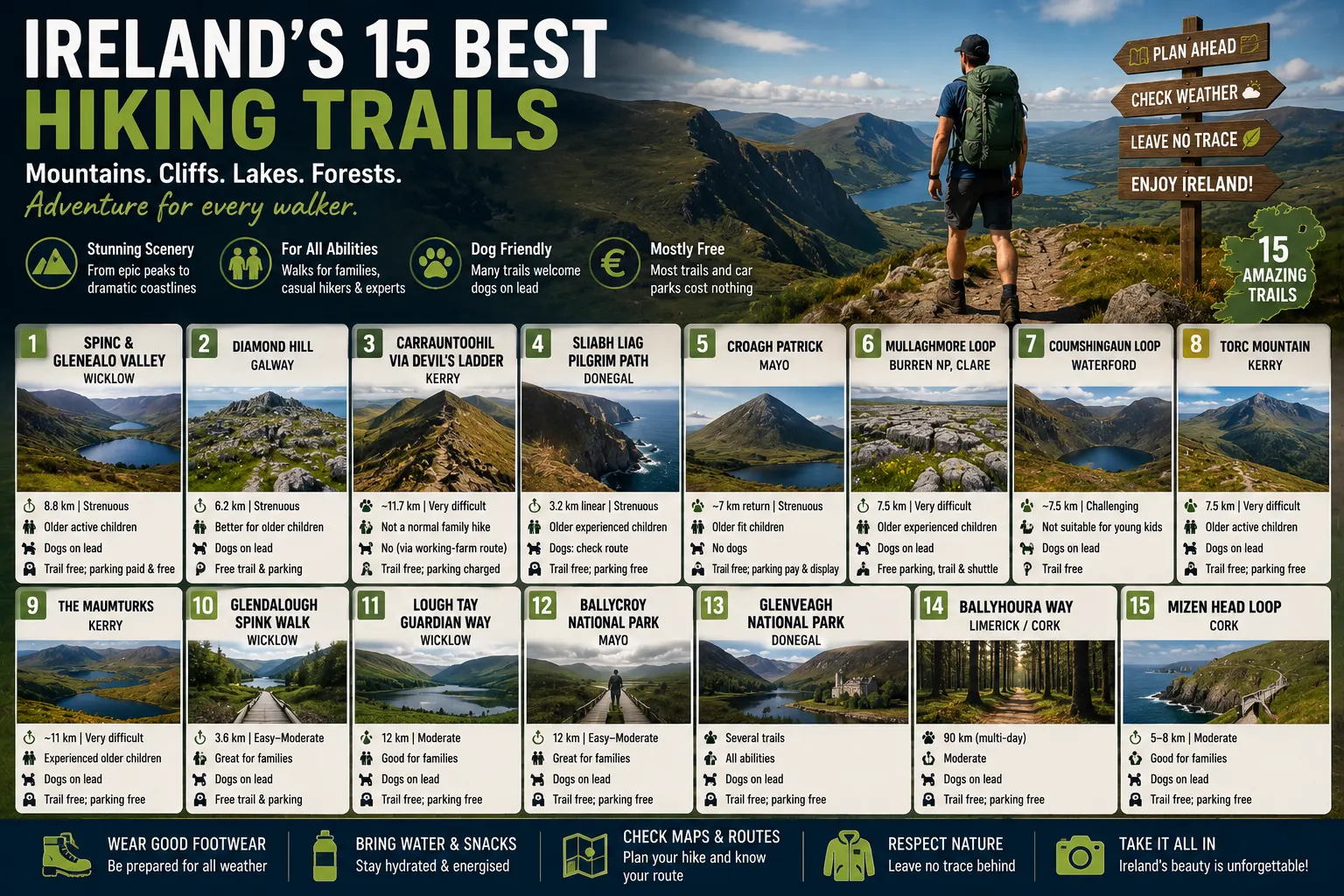
From the boardwalk high above Glendalough to the limestone wilderness of the Burren and the summit of Carrauntoohil, Ireland offers exceptional walks for almost every level of ability. Our 2026 guide selects 15 of the country’s most rewarding trails and explains their length, difficulty, parking, likely costs, suitability for children and rules for dogs.
Ireland is a comparatively small country, yet its walking landscape changes remarkably quickly. A morning can begin on a trail overlooking Atlantic sea cliffs and the next day lead through ancient woodland, across exposed mountain ridges or around a glacial lake. Many of the country’s finest routes are also remarkably inexpensive: National Park admission is generally free, numerous forest car parks cost nothing and some of the most memorable walking experiences require little more than appropriate footwear and preparation.
What varies enormously is difficulty. The family-friendly Benbulben Forest Walk and Mullaghmeen trails belong in a very different category from Carrauntoohil, Coumshingaun or the upper reaches of Sliabh Liag. A distance of only six or seven kilometres can represent a relaxed two-hour walk on one trail and a demanding mountain expedition on another.
The following Ireland Newspaper Top 15 is an editorial selection, not an official ranking. Scenic quality, variety, national significance, accessibility and the overall walking experience have all been considered. Trail information has been checked against current National Parks of Ireland, Fáilte Ireland, Sport Ireland, Coillte, local tourism and visitor-centre information available in August 2026.
Where a trailhead has an official Eircode, it is provided. Rural mountain car parks often do not have their own postal address or Eircode; in those cases, the named car park, visitor centre, coordinates or nearest recognised location are more reliable than inventing a postcode.
Ireland’s Top 15 Hiking Trails at a Glance
| Rank | Hiking trail | County | Distance | Difficulty | Children | Dogs | Trail / parking cost |
|---|---|---|---|---|---|---|---|
| 1 | Spinc & Glenealo Valley | Wicklow | 8.8 km | Strenuous | Older active children | Yes, on lead | Trail free; parking options include paid and free |
| 2 | Diamond Hill | Galway | 6.2 km | Strenuous | Better for older children | Yes, on lead | Free trail and parking |
| 3 | Carrauntoohil via Devil’s Ladder | Kerry | ~11.7 km | Very difficult | Not a normal family hike | No via working-farm approach | Trail free; private parking charged |
| 4 | Sliabh Liag Pilgrim Path | Donegal | 3.2 km linear | Strenuous | Older experienced children only | Check chosen route; dogs need strict control in wider area | Trail free; main centre parking free |
| 5 | Croagh Patrick | Mayo | ~7 km return | Strenuous | Older fit children | No | Trail free; parking is pay-and-display |
| 6 | Mullaghmore Loop, Burren National Park | Clare | 7.5 km | Very difficult | Older experienced children | Yes, on lead | Free parking, trail and seasonal shuttle |
| 7 | Coumshingaun Loop | Waterford | ~7.5 km | Challenging | Not suitable for young children | On lead; check local signs | Trail free |
| 8 | Torc Mountain | Kerry | 7.5 km | Very difficult | Older active children | Yes, on lead | Free trail and parking |
| 9 | Benbulben/Gortarowey Loop | Sligo | 5.5 km | Easy | Very good | Yes | Trail free |
| 10 | Howth Cliff Path Loop | Dublin | 7.8 km | Moderate | Good with supervision | Yes, preferably on lead | Free trail; Howth DART parking free but very limited |
| 11 | Great Sugar Loaf | Wicklow | Approx. 3–4 km return | Moderate, rocky summit | Good for confident older children | Yes | Free trail and parking |
| 12 | Glenveagh Lakeside Walk | Donegal | 3.5 km one way | Moderate | Excellent | Yes, on lead | Park/parking free; optional bus costs extra |
| 13 | Ticknock Fairy Castle Loop | Dublin | 6 km | Moderate | Good for active children | Yes | Free trail |
| 14 | Glenbarrow Waterfall Loop | Laois | 4.2 km | Strenuous | Good for active older children | Yes | Free trail and parking |
| 15 | Mullaghmeen Forest Red Trail | Westmeath | Up to 8 km | Moderate | Excellent | Yes, on lead | Free parking |
Difficulty ratings are based primarily on official trail classifications rather than distance alone. Family suitability is an editorial guide: parents should assess their children’s fitness, experience and comfort with heights, uneven ground and changing weather before setting out.
1. The Spinc and Glenealo Valley — Glendalough, County Wicklow
There are more difficult mountains and longer walking routes in Ireland, but few trails combine scenery, history and accessibility as successfully as the Spinc. The route climbs steeply above Glendalough’s Upper Lake before following the high ground on a distinctive boardwalk. From there, walkers look down over one of Ireland’s most famous glacial valleys before descending through the Glenealo Valley and the old miners’ settlement.
The official route is approximately 8.8km, graded strenuous and normally takes around three and a half hours. The early ascent beside Poulanass Waterfall involves a considerable number of steps, and wet timber, exposed sections and changing mountain weather mean proper footwear remains important even though much of the trail is well constructed.
Trailhead and parking: Glendalough has several useful parking choices. The Visitor Centre car park and Upper Lake car park can carry charges, while the National Park identifies the Laragh car park as a free alternative. The Visitor Centre is at Glendalough, County Wicklow, A98 HC80.
Cost: Walking the trail itself is free. Parking costs depend on which car park is used; the National Park does not currently publish one universal Glendalough parking tariff because the car parks are operated under different arrangements. The visitor-centre exhibition is a separate attraction and is not required for the hike.
Children: The complete Spinc is best regarded as a walk for older, active children who already have hill-walking experience rather than a route for very young children. National Park guidance has itself noted that the route can be too long for young children.
Dogs: Dogs are welcome in Wicklow Mountains National Park but must remain on a lead at all times, both to protect wildlife and because sheep graze within parts of the park.
For visitors who have only one day available for hiking in Wicklow, the Spinc is difficult to beat. It provides a genuine mountain experience without requiring the navigation skills needed on many unmarked Irish summits.
2. Diamond Hill — Connemara National Park, County Galway
Diamond Hill achieves something unusual: it gives walkers the visual rewards of a major Connemara mountain while beginning directly beside a staffed National Park visitor centre.
The full route is approximately 6.2km, gains around 400 metres and is officially graded strenuous. Most walkers should allow around two hours, although families and photographers may want considerably longer. From the higher trail, views spread across the Twelve Bens, Kylemore, the Atlantic coastline and the extraordinary patchwork of bog, mountain and water that defines Connemara.
Trailhead and parking: Connemara National Park Visitor Centre, Letterfrack, County Galway, H91 K2Y1. Both admission and parking are free.
Cost: €0 for the trail and €0 for parking.
Children: Families do not necessarily have to attempt the summit. The lower Diamond Hill route provides a shorter alternative, while the complete upper route is more appropriate for older children who are comfortable with sustained climbing, steps and exposed mountain conditions. The visitor-centre area also has picnic space and a playground, making this one of the easier mountain destinations around which to organise a family day.
Dogs: Dogs are welcome but must stay on a lead throughout the National Park.
Diamond Hill is particularly useful for visitors beginning to progress from forest walks to genuine mountain hiking. The trail is substantial enough to feel like an achievement without requiring the technical judgement demanded by Ireland’s highest mountains.
3. Carrauntoohil via the Devil’s Ladder — County Kerry
At 1,038 metres, Carrauntoohil is Ireland’s highest mountain, and the traditional approach through Hag’s Glen and the Devil’s Ladder remains one of the country’s defining mountain days.
This is not simply a longer version of an ordinary marked walking trail. Discover Ireland describes the climb as suitable for experienced hikers, and a typical Devil’s Ladder outing covers around 11.7km and six to seven hours, depending on route, conditions and pace. Loose rock, rapidly changing weather, steep gradients and difficult navigation when cloud descends make preparation essential.
Trailhead and parking: Cronin’s Yard, Mealis, Beaufort, County Kerry, V93 HK71.
Cost: There is no admission fee to climb the mountain. Cronin’s Yard operates private parking and visitor facilities; a parking charge applies, although the current amount is not prominently published in the official information and should be confirmed before travelling.
Children: Carrauntoohil should not be promoted as an ordinary children’s hike. Experienced and properly equipped teenagers who already have substantial mountain experience may climb it with competent adults or a professional guide, but the Devil’s Ladder is inappropriate as an introductory family hill walk.
Dogs: The approaches cross working farmland. The official Cronin’s Yard walking route is listed as not allowing dogs, so hikers should not plan to bring a dog on this approach.
Carrauntoohil earns its place near the top of this list because it represents the upper end of Irish recreational hiking. Reaching the summit in good conditions provides spectacular views across MacGillycuddy’s Reeks, but turning back when weather deteriorates is part of good mountain judgement, not a failed hike.
4. Sliabh Liag Pilgrim Path — County Donegal
Sliabh Liag offers an entirely different form of height. Instead of standing deep inside a mountain range, walkers rise above the Atlantic on cliffs whose faces exceed 600 metres.
The officially promoted Sliabh Liag Pilgrim Path is a 3.2km linear route, while more demanding extensions around the high ground and One Man’s Pass are suitable only for experienced walkers. Discover Ireland specifically warns that only experienced hikers should continue beyond the principal viewing areas onto the more serious upper routes.
Visitor base and parking: A particularly useful starting point for first-time visitors is Slieve League Cliffs Centre, Bunglass Road, Teelin, County Donegal, F94 EV52. The centre provides information, food and visitor services.
Cost: The cliffs and walking access are free, and Discover Ireland lists free car parking. Shuttle buses and guided services are separate commercial or visitor services and can involve additional costs.
Children: The main viewpoints can be enjoyed as a family outing, but the Pilgrim Path and especially the high-level extensions should be reserved for older, experienced children or teenagers. Cliff exposure and Atlantic weather make supervision essential.
Dogs: Discover Ireland describes the wider Sliabh Liag attraction as dog-friendly, but the mountain environment contains livestock, cliff edges and sensitive habitats. Dogs should therefore remain securely controlled and owners should obey any route-specific signage.
The great attraction of Sliabh Liag is choice. A family can experience magnificent cliff scenery without undertaking the most demanding terrain, while strong walkers can turn the visit into a serious mountain hike.
5. Croagh Patrick — Murrisk, County Mayo
Croagh Patrick is simultaneously a mountain, pilgrimage route and one of the great viewpoints over Ireland’s western coastline.
The standard climb from Murrisk is approximately 7km return. Discover Ireland recommends allowing around three to four hours for the full climb and describes the ascent as strenuous. The final part becomes considerably rougher and steeper, and the descent over loose stone can demand as much concentration as the climb.
Trailhead and parking: Croagh Patrick Visitor Centre, Reek Road, Murrisk, County Mayo, F28 KX75. The official visitor site places the centre directly at the foot of the mountain.
Cost: Climbing Croagh Patrick is free. The main Murrisk parking facility is pay-and-display; the exact current charge should be checked locally because the public tourism information confirms paid parking without publishing a reliable single 2026 tariff.
Children: Fit older children and teenagers regularly tackle the mountain, but the combination of continuous climbing, loose rock and exposed weather means it is not an ideal first mountain for very young children.
Dogs: Dogs are not permitted on Croagh Patrick. The mountain crosses private working farmland, and Leave No Trace Ireland specifically asks visitors not to bring dogs beyond the gate onto the Reek. Local pilgrimage guidance gives the same instruction.
The summit may be only 764 metres above sea level, but its position above Clew Bay creates a view that feels far bigger. On a clear day, the islands scattered below are one of the finest rewards on any Irish climb.
6. Mullaghmore Loop — Burren National Park, County Clare
The Burren is proof that Ireland’s most dramatic hiking landscapes do not always have to be green.
The Mullaghmore Loop is 7.5km and is officially graded very difficult by National Parks of Ireland. The route crosses remote limestone upland, passes Lough Gealáin and traverses the enormous sheets of fractured limestone pavement that make the Burren internationally distinctive. Although the total ascent is only around 140 metres, the rough surface makes the route considerably more demanding than the elevation figure suggests.
Best parking strategy: Rather than trying to park at the rural trailhead, National Parks recommends beginning at the Burren National Park Information Point, Corofin, County Clare, V95 VX83. Parking in Corofin is free. During the visitor season a free shuttle operates between Corofin and the National Park trailhead, reducing congestion on the narrow roads around Gortlecka.
Cost: Trail free, Corofin parking free and seasonal National Park shuttle free.
Children: The full Mullaghmore Loop is best for older children with real walking experience. Families with younger children have an excellent alternative: the 1.3km Knockaunroe Turlough route is officially described as suitable for all ages and fitness levels.
Dogs: Dogs are permitted in Burren National Park only on a lead at all times. Livestock may graze parts of the park.
For walkers accustomed to Ireland’s bogs and green mountains, Mullaghmore can feel almost like another country. The landscape’s exposed limestone, rare flora and glacial geology make it one of the most distinctive walks in the Top 15.
7. Coumshingaun Loop — Comeragh Mountains, County Waterford
Coumshingaun is one of those Irish locations that can appear almost impossibly dramatic in good weather. A dark corrie lake sits beneath a great amphitheatre of mountain cliffs, with the Waterford countryside spreading towards the coast behind the walker.
Visit Waterford describes the complete Coumshingaun Loop as a challenging four-to-five-hour hike, while its published trail guide gives a distance of approximately 7.5km. The route involves steep climbing, exposed high ground and sections where navigation becomes important, particularly if mist descends.
Trailhead and parking: Kilclooney Wood Car Park, Comeragh Mountains, County Waterford. Coillte identifies Kilclooney as an established parking and picnic area on the lower slopes of the Comeraghs. The rural car park does not have a reliable dedicated Eircode published for visitors, so navigating by the named Kilclooney Wood Car Park is safer.
Cost: There is no admission charge for the mountain route. No current separate parking tariff is published by Coillte for Kilclooney.
Children: The full ridge loop is not recommended for young children. A much easier alternative is to walk towards the lower lake and return without completing the exposed high-level circuit.
Dogs: Dogs are reported as permitted on the route, but sheep and other livestock can be encountered. A lead and close control are essential, and current trailhead signage should take precedence over general online guidance.
Coumshingaun is particularly rewarding for experienced walkers who want a serious mountain experience without attempting one of Ireland’s highest summits.
8. Torc Mountain — Killarney National Park, County Kerry
Torc Mountain offers one of Ireland’s best combinations of forest, mountain and lake scenery.
The route from Upper Torc climbs through woodland before joining mountain paths, boardwalk and stone steps towards the 535-metre summit. Current Killarney trail information gives the route as approximately 7.5km, around two hours, and grades it very difficult, reflecting its steep and sometimes rough terrain rather than exceptional distance.
Parking: The most direct starting point is Upper Torc Car Park, reached from the Old Kenmare Road above Torc Waterfall. There is no dependable dedicated Eircode for this small mountain car park, so visitors should navigate by the car-park name rather than borrowing an Eircode from a nearby hotel or attraction.
Cost: Entry to Killarney National Park and its public parking areas is free. National Parks asks visitors to use larger parking areas where possible during busy periods because small locations such as Torc can fill quickly.
Children: Suitable for fit older children accustomed to hills. Younger families may prefer the lower walks around Torc Waterfall, Muckross or the lakes.
Dogs: Dogs are welcome in Killarney National Park but must be on a lead.
At the summit, the effort is repaid with views towards the Lakes of Killarney, MacGillycuddy’s Reeks and the surrounding National Park — an enormous landscape packed into a relatively short hike.
9. Benbulben Forest Walk — Gortarowey, County Sligo
Not every great Irish hike needs to involve scrambling, exposure or four hours of climbing. The Benbulben Forest Walk at Gortarowey is one of the country’s best examples of a route that delivers exceptional scenery without extreme difficulty.
The main Benbulben loop is approximately 5.5km, classified as easy and takes roughly one hour and fifteen minutes. The total climb is only around 45 metres. From the forest and open sections, walkers gain impressive views of Benbulben’s distinctive table-like mountain face and the surrounding Sligo countryside.
Trailhead: Gortarowey Forest Recreation Area, County Sligo. Coillte provides a designated car park. The recreation site does not publish a dedicated Eircode, so search for Gortarowey / Benbulben Forest Walk rather than using a nearby private property’s code.
Cost: Walking is free. No current parking charge is listed by Coillte for this recreation site.
Children: Excellent. Discover Ireland specifically presents the trail as suitable for family and friends, and the modest gradients make it one of the strongest family choices in this Top 15.
Dogs: Yes. Dogs are listed as allowed on the walking route; using a lead remains sensible where wildlife, other walkers or grazing animals are present.
Benbulben Forest Walk is a particularly good recommendation for visitors who want dramatic mountain photographs but do not want to undertake a summit climb.
10. Howth Cliff Path Loop — County Dublin
Few European capitals have a walk of this quality accessible by suburban railway.
Beginning at Howth DART station, the 7.8km Cliff Path Loop passes the harbour before rising towards the cliffs around Howth Head. Discover Ireland grades it moderate, records around 130 metres of ascent and suggests approximately two hours. Rougher ground makes walking shoes preferable to ordinary city footwear.
Trailhead and parking: Howth DART Station, Howth, Dublin 13, D13 N8K7. Iarnród Éireann currently lists only 10 station parking spaces, but they are free and available 24 hours. Given the limited supply and the fact that the route begins at the railway station, arriving by DART is often the easier option.
Cost: Trail free; station parking free, subject to availability.
Children: Good for active school-age children, but this is a genuine cliff walk. Children should remain close to an adult wherever the path approaches exposed cliff edges, particularly in wind.
Dogs: Dogs are commonly walked on Howth Head, but owners should use a lead around cliff edges, wildlife and conservation grazing. Fingal’s conservation work on the headland specifically asks walkers to keep dogs leashed around grazing animals.
Howth’s other great advantage is what happens when the walking ends. The route returns hikers to a harbour village with cafés, pubs, seafood restaurants and public transport rather than an isolated mountain car park.
11. Great Sugar Loaf — County Wicklow
The Great Sugar Loaf is one of those mountains whose appearance exaggerates its scale. Its sharp conical profile makes it look like a major peak even though the summit stands at only about 501 metres.
The commonly used southern approach is relatively short and can be completed up and down in a little over an hour by fit walkers, but the final section involves a genuine rocky scramble. Discover Ireland therefore describes it as family-friendly while warning visitors to expect scrambling near the summit.
Parking: The usual access is from the southern side near the L1031/Red Lane approach outside Kilmacanogue, County Wicklow. The rural parking area has no dedicated official Eircode, so use the named Great Sugar Loaf car park or local navigation coordinates rather than a neighbouring home’s postcode.
Cost: Trail free and parking free.
Children: Good for confident, active children, but young children may find the final rocky section intimidating. Close supervision is necessary during the scramble and descent.
Dogs: Discover Ireland lists the mountain as dog-friendly. Because livestock can be present and the upper route becomes rocky, dogs should remain under close control and preferably on a lead.
Its great reward is location. From the summit, walkers can look north towards Dublin, west into the Wicklow Mountains and east towards the Irish Sea — an exceptional panorama for a relatively short outing.
12. Glenveagh Lakeside Walk — County Donegal
Glenveagh National Park contains serious mountain country, but one of its loveliest walks is accessible to almost everybody.
The Lakeside Walk is 3.5km, officially graded moderate and follows a mostly flat gravel path from the visitor-centre area towards Glenveagh Castle. Throughout the walk, Lough Veagh remains close by while the surrounding mountains create the feeling of a far more remote journey.
Trailhead and parking: Glenveagh National Park Visitor Centre, Churchill, County Donegal, F92 P993. Parking and general access to the National Park are free.
Cost: Walking and parking are free. An optional shuttle bus links the visitor centre and castle. In 2026, the standard fare is €5 adult return or €3 single, while youth, students and seniors pay €4 return or €2 single; children under six travel free.
Children: Excellent. The mostly level surface, visitor facilities and option of using the return bus make this one of the strongest family walks anywhere in the national-park system.
Dogs: Dogs are welcome on a lead, but there is one important practical catch: dogs other than service animals cannot travel on the shuttle bus. Anyone bringing a dog should therefore be prepared to walk back, turning the outing into approximately 7km.
Glenveagh is a useful reminder that a beautiful hiking day need not end on a summit. The combination of lake, castle, woodland and mountains makes the valley itself the destination.
13. Ticknock Fairy Castle Loop — Dublin Mountains
Ticknock is Dublin’s mountain escape: close enough for an afternoon trip from the city but high enough to provide genuine open-mountain views.
The Fairy Castle Loop covers 6km, climbs approximately 210 metres and takes around one hour and 45 minutes. Discover Ireland grades the route moderate. It crosses forest road and mountain path through Three Rock before climbing towards Two Rock and the cairn known as Fairy Castle at 536 metres.
Trailhead: Ticknock Forest Entrance Car Park, Sandyford, County Dublin. There is no dedicated official Eircode for the forest entrance. Coillte lists approximately 100 parking spaces and, importantly, current opening hours of 06:00 to 22:00. Drivers should ensure they are back before the gates close.
Cost: The walking trail is free. Coillte’s current Ticknock page does not list a separate day-parking tariff.
Children: Suitable for active school-age children comfortable with a two-hour hill walk. The route is a good intermediate step between family forest walking and more serious mountain hikes.
Dogs: Yes. Discover Ireland lists dogs as permitted. They should remain under control, particularly once the route leaves the forest and enters open mountain terrain.
Few trails provide such an abrupt visual transition: walkers leave the forest and suddenly find Dublin city, Dublin Bay and the Wicklow Mountains spread beneath them.
14. Glenbarrow Waterfall Loop — Slieve Bloom Mountains, County Laois
Glenbarrow delivers an unusually large amount of scenery in just over four kilometres.
The Waterfall Loop covers 4.2km, takes around 90 minutes and follows sections of the River Barrow through woodland to a striking three-tier waterfall. Although total recorded ascent is modest, Discover Ireland grades the trail strenuous because sections of the riverside terrain are rough, steep and frequently wet.
Trailhead and parking: Glenbarrow Forest Entrance Car Park, near Clonaslee, County Laois. The remote forest car park does not have a dedicated published Eircode. Coillte says the improved parking area accommodates more than 50 vehicles and warns that it can fill on sunny weekends.
Cost: Trail free and parking free.
Children: Suitable for active older children, particularly those comfortable on rocky and sometimes muddy paths. It is not a buggy route and extra care is needed close to fast-flowing water after rain.
Dogs: Yes on the Waterfall Loop.
For families wanting more distance, Glenbarrow also has longer routes, including the 8.3km Old Mill Loop. The short Waterfall Loop, however, provides the best balance of scenery and manageable distance.
15. Mullaghmeen Forest — County Westmeath
Ireland’s great walking landscapes are usually associated with the coast or mountains, which makes Mullaghmeen a particularly appealing final choice.
The forest is Ireland’s largest planted beech forest and contains three looped trails ranging from approximately 3km to 8km. The longest reaches the summit of Mullaghmeen and normally takes just over two hours, with views north towards Lough Sheelin and County Cavan.
Trailhead and parking: Mullaghmeen Forest, near Finnea, County Westmeath, approximately 8km west of Oldcastle. There is no dedicated trailhead Eircode published by Coillte, so motorists should navigate by the named Mullaghmeen Forest recreation site.
Cost: Parking is free, and there is no entrance charge.
Children: Excellent. Gravel forest tracks and a choice of distances allow families to select a route appropriate to the youngest walker rather than committing everyone to one long circuit.
Dogs: Dogs are welcome on a lead.
Mullaghmeen may lack the drama of Carrauntoohil or Sliabh Liag, but that is part of its strength. It offers an accessible, peaceful woodland experience and gives families a place where walking can be enjoyed without turning the day into an expedition.
Which Trail Is Best for Families?
The term “family-friendly” needs to be used carefully in Irish hiking. A seven-year-old who regularly walks hills with their parents may be far more capable than an inexperienced teenager, while weather can transform an apparently straightforward route.
For younger families, Benbulben’s Gortarowey Loop, Glenveagh Lakeside Walk and Mullaghmeen Forest are the strongest options on this list. They combine manageable terrain with scenery and straightforward access. Diamond Hill can also work extremely well because families can remain on the lower trails rather than committing to the summit.
Howth, Ticknock, Great Sugar Loaf and Glenbarrow make good next steps for children who already enjoy walking. They introduce more climbing, rough ground or exposure without reaching the seriousness of Ireland’s major mountain routes.
Carrauntoohil, the full Coumshingaun Loop, the high routes at Sliabh Liag and the full Mullaghmore Loop in the Burren should be treated differently. They require fitness, suitable clothing, competent judgement and respect for mountain weather. National Parks describes the Burren’s very-difficult routes as suitable for competent mountain walkers, while Discover Ireland similarly reserves Carrauntoohil’s traditional climb for experienced hikers.
Bringing a Dog Requires More Planning Than Checking the Distance
Ireland does not have one universal rule covering dogs on hiking trails.
Within Wicklow, Connemara, Burren and Glenveagh National Parks, dogs can generally accompany walkers but must remain on a lead. Killarney National Park similarly expects dogs to remain controlled. On routes crossing private agricultural land, however, the position can be completely different. Croagh Patrick specifically prohibits dogs, and numerous official waymarked trails crossing farmland do the same.
This is not simply an administrative restriction. Sheep worrying is a serious issue in upland Ireland, particularly during lambing, and even a dog that normally behaves perfectly can cause livestock to panic.
The sensible rule is therefore straightforward: never assume a dog is allowed because another mountain permits one, and never interpret “dog-friendly” as meaning “off lead”. Check the individual trail, obey signs at the trailhead and keep dogs close around livestock and wildlife.
Parking Is Often the Only Cost — but Arriving Early Matters
One of the strongest features of hiking in Ireland is how much of it remains free.
Diamond Hill offers free National Park access and free parking. The Burren combines free parking in Corofin with a free seasonal shuttle. Benbulben, Great Sugar Loaf, Glenbarrow and Mullaghmeen can also be enjoyed without paying an attraction entrance fee. Howth can be reached directly by DART and its tiny station car park is currently free.
The problem is often availability rather than price.
Popular mountain car parks are small relative to demand. Coillte warns that Glenbarrow can fill on sunny weekends, Howth station has only ten parking spaces, and the National Parks increasingly encourage visitors to use larger car parks or shuttle systems instead of crowding rural roads.
Parking on verges, blocking farm gates or narrowing already small mountain roads can create problems for residents and emergency vehicles. On the busiest summer weekends, arriving early or using public transport can improve the day considerably.
Why an Eircode Cannot Always Be Provided
An Irish Eircode identifies a postal address rather than every geographic location.
That distinction matters in mountain areas. Visitor centres such as Glendalough A98 HC80, Connemara H91 K2Y1, Sliabh Liag F94 EV52 and the Burren Information Point V95 VX83 have reliable Eircodes because they are buildings receiving post. An isolated forest gate or gravel mountain car park often does not.
Using the Eircode of the nearest house simply to provide a code can be worse than providing none at all: it can direct visitors onto private property.
For trailheads without an official Eircode, the safest navigation method is therefore the exact named car park supplied in this guide, together with an official National Park, Coillte, Sport Ireland or Discover Ireland map.
Irish Weather Can Change the Difficulty Completely
The numerical grade beside a trail name should never replace a weather check.
A moderate path can become difficult when timber is icy or stone is wet. A demanding but navigable mountain can become dangerous when cloud removes visibility. Connemara National Park closes its grounds during Orange and Red weather warnings, while Coillte states that people should not enter forest areas during a Red wind warning.
For serious mountain routes, hikers should carry waterproof clothing, warm layers, adequate food and water and a navigation method that does not depend entirely on mobile reception. Proper walking boots are particularly important on Carrauntoohil, Coumshingaun, Croagh Patrick and the Burren’s rough limestone.
A simple rule works well in Ireland: if the weather makes the mountain substantially different from the walk you prepared for, change the plan.
Fifteen Trails, Fifteen Different Versions of Ireland
The most interesting feature of this Top 15 is how little the walks resemble one another.
Glendalough combines a glacial valley with a high boardwalk. Diamond Hill opens onto the Twelve Bens. Carrauntoohil is a serious mountain objective. Croagh Patrick connects hiking with more than a millennium of pilgrimage tradition. Sliabh Liag puts the Atlantic hundreds of metres beneath the walker, while the Burren replaces Ireland’s familiar green hills with vast exposed limestone.
Elsewhere, Torc Mountain looks across Killarney’s lakes, Coumshingaun surrounds walkers with the walls of a glacial corrie, Benbulben delivers extraordinary scenery without a punishing ascent, and Howth places a genuine coastal hike at the end of a Dublin railway line.
That diversity also means there is no need to choose Ireland’s hardest walk to experience one of its best.
For a family introducing children to hiking, a successful afternoon at Glenveagh or Mullaghmeen may be a much better adventure than struggling halfway up a major mountain. For an experienced walker, by contrast, Carrauntoohil or Coumshingaun can provide the challenge that a forest loop cannot.
The best Irish hiking trail is ultimately not simply the highest, longest or most photographed one. It is the route that matches the walker — and leaves enough energy at the end of the day to want to see where the next trail leads.
Source & Transparency
This article is published by Ireland Newspaper for editorial and informational purposes.
Published: 13 August 2026 · Updated: 13 August 2026

Newsroom Ireland Newspaper
Ireland Newspaper editorial team prepares daily news coverage for readers in Ireland and abroad.