
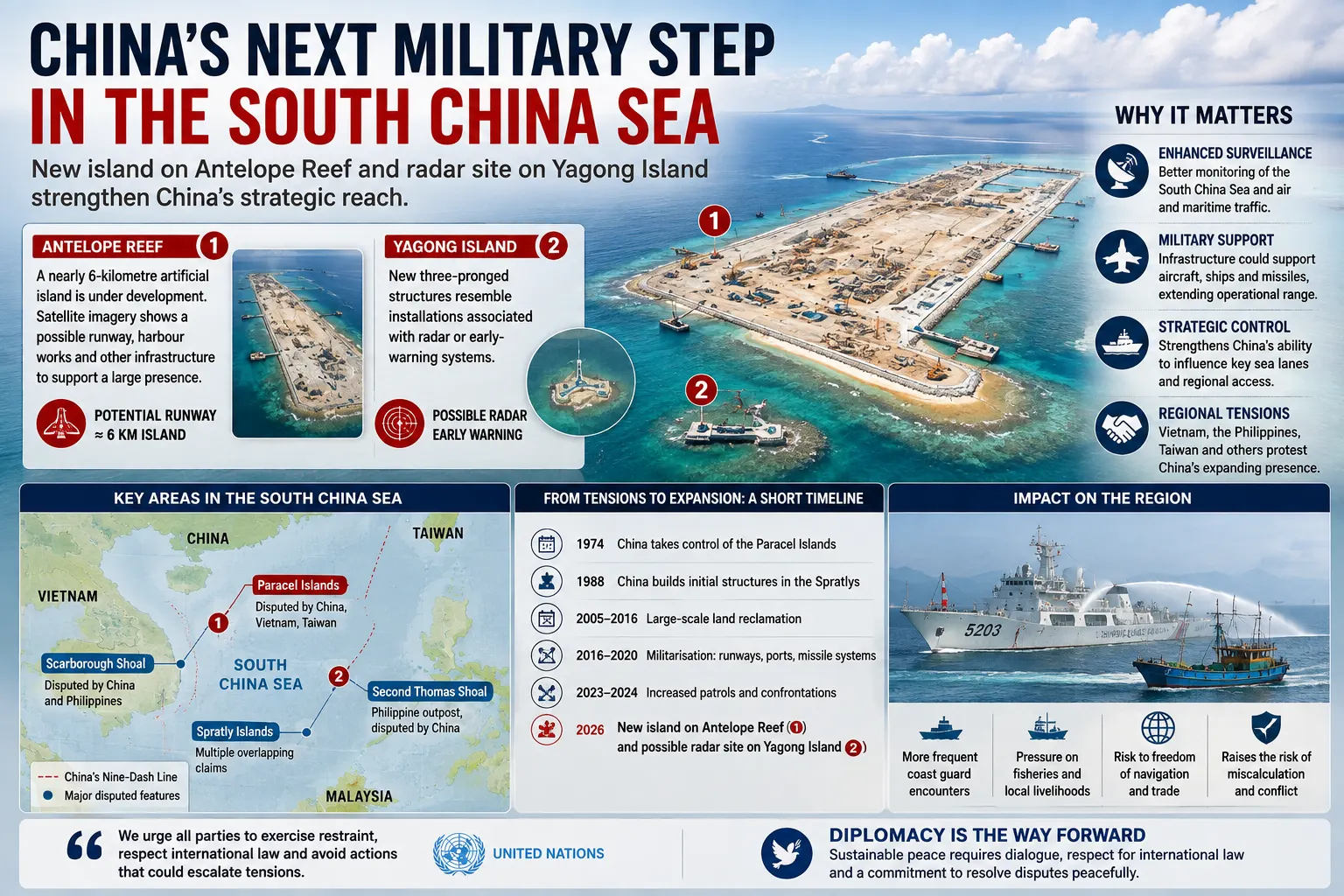
A nearly six-kilometre artificial island taking shape on Antelope Reef and possible new early-warning installations on nearby Yagong Island have provided the clearest recent evidence that China’s strategic expansion in the South China Sea is entering another phase. Satellite imagery reviewed in August 2026 indicates that construction is no longer confined to the large bases Beijing established farther south in the Spratly Islands. It is also strengthening the Paracels, closer to the Chinese mainland, Vietnam and the northern approaches linking the South China Sea with the Taiwan theatre.
The construction does not by itself demonstrate that a major military confrontation is imminent. Beijing says its activities in the South China Sea protect Chinese sovereignty and maritime rights, and state media have described facilities at Antelope Reef as serving civilian purposes including weather forecasting, fisheries protection and scientific research. Yet the physical characteristics of the new island, the expansion of surveillance infrastructure elsewhere, frequent naval and coastguard patrols and increasingly sophisticated exercises are collectively altering what China can monitor, support and potentially control across the region.
The change matters because the South China Sea is simultaneously an international shipping corridor, a source of fish and potential energy resources, an arena of overlapping sovereignty claims and a route connecting China’s southern military commands with the wider Pacific. Disputes that once centred primarily on small reefs and fishing grounds are now connected to coastguard confrontations, missile systems, drone surveillance, alliance commitments and preparations for a possible crisis involving Taiwan.
The Latest Construction Is Strategically Significant
China completed the first stage of reclamation at Antelope Reef in the disputed Paracel Islands during 2026. Satellite imagery reviewed by Reuters in August showed an artificial island almost six kilometres long after months of dredging. Analysts examining the imagery identified a long straight section of coastline that could accommodate a substantial runway, as well as harbour-related works and other infrastructure capable of supporting a much larger permanent presence.
The exact final configuration of Antelope Reef remains uncertain. A potential runway was not yet a completed operational airfield when the imagery was assessed, and China had not announced that the project would become a military base. That distinction is important. Infrastructure that can eventually support military operations is not automatically evidence that every element has already been assigned a military function.
Days later, attention shifted about 14 kilometres northeast to Yagong Island. Commercial satellite provider Vantor identified new three-pronged structures whose design resembled installations associated elsewhere with radar or early-warning functions. Analysts interviewed by Reuters said radar was a plausible explanation, potentially allowing Yagong to support the larger development at Antelope, although they stressed that the purpose could not yet be established conclusively.
Vietnam responded on 28 August by demanding an end to the activity, describing construction in the Paracels as a violation of Vietnamese sovereignty. China has controlled the Paracel archipelago since its forces defeated South Vietnamese forces there in 1974, but Vietnam continues to claim the islands. Taiwan also maintains territorial claims in parts of the wider South China Sea.
Key Areas in the Current South China Sea Dispute
| Area | Current Significance | Main Claims or Dispute |
|---|---|---|
| Paracel Islands | Rapid Chinese infrastructure expansion, including Antelope Reef | China, Vietnam and Taiwan maintain claims |
| Spratly Islands | Major Chinese bases and competing regional outposts | Multiple overlapping claims |
| Scarborough Shoal | Frequent China-Philippines confrontation and fishing dispute | China and Philippines dispute control and rights |
| Second Thomas Shoal | Philippine military outpost and recurring resupply confrontations | China challenges Philippine presence |
| Taiwan approaches | Chinese blockade and encirclement exercises increasingly relevant | Separate sovereignty dispute with wider regional consequences |
Sources: Permanent Court of Arbitration, Reuters, Chinese Ministry of Foreign Affairs and governments of regional claimant states.
China’s Presence Is Much Larger Than Its Navy
It is tempting to measure China’s influence in the South China Sea by counting warships, but that misses much of the strategy. Beijing operates through several overlapping layers: the People’s Liberation Army Navy, the China Coast Guard, civilian and maritime law-enforcement agencies, fishing fleets that include vessels identified by regional governments as maritime militia, and permanent infrastructure constructed on disputed features.
This layered presence allows China to exert pressure without routinely deploying naval destroyers directly against another claimant’s civilian ships. Coastguard vessels can enforce Beijing’s interpretation of maritime jurisdiction, escort fishing activity and challenge foreign government vessels while keeping an incident below the threshold normally associated with conventional warfare. Military forces remain available behind that first line.
The distinction between civilian law enforcement and military power is nevertheless becoming less clear during exercises. On 1 August, Chinese forces conducted naval and air activity around Scarborough Shoal alongside coastguard operations. On 26 August, China’s Southern Theater Command announced that naval and air units had carried out several days of patrols in the South China Sea, saying the activity was a response to Philippine cooperation with countries from outside the region.
China describes these operations as lawful activities necessary to protect sovereignty, maritime rights and regional stability. The Philippines and several of its security partners view the same pattern as coercive because Chinese ships operate in waters Manila regards as falling within its exclusive economic zone under the United Nations Convention on the Law of the Sea.
The Artificial Islands Changed What China Can Do at Sea
The strategic transformation began well before the latest construction. During the previous decade China created large artificial islands in the Spratly chain, particularly at Fiery Cross, Mischief and Subi reefs. Those outposts subsequently acquired long runways, hangars, harbour facilities, radar installations, defensive systems and other infrastructure.
The significance of the islands is logistical as much as symbolic. Aircraft and ships operating hundreds of kilometres from the Chinese mainland need fuel, maintenance, communications and surveillance. Permanent facilities reduce dependence on distant mainland bases and enable a state to maintain a much more persistent presence than ships operating independently for limited periods.
Recent satellite analysis by the Asia Maritime Transparency Initiative has identified further upgrades to intelligence, surveillance, reconnaissance and electronic-warfare infrastructure across China’s major Spratly outposts. New antenna arrays and areas apparently designed for mobile electronic systems were installed after 2022, indicating that the bases continue to evolve even where major land reclamation had already ended.
Antelope Reef potentially extends this architecture northwards. Its position in the western Paracels could improve surveillance and logistics across the northern South China Sea and approaches towards Hainan, where China maintains important naval facilities. Security analysts also consider the area relevant to any future Taiwan contingency because forces moving between the South China Sea and the western Pacific would operate through connected maritime corridors.
The South China Sea Dispute Is Not One Territorial Argument
There is no single South China Sea dispute with only two participants. China, Vietnam, the Philippines, Malaysia, Brunei and Taiwan hold overlapping claims to different islands, reefs, waters and maritime rights. Indonesia does not claim the main Spratly or Paracel island groups but has objected when Chinese maritime claims or activities overlap with areas Jakarta considers part of Indonesia’s exclusive economic zone around the Natuna Islands.
China bases its position on sovereignty over island groups it calls Nanhai Zhudao and maintains that it possesses associated maritime entitlements and historic rights. Its maps have for decades depicted a broad dashed-line claim covering much of the South China Sea. Beijing says its sovereignty and rights are supported by history and international law and accuses outside powers of exploiting the disputes to contain China.
Southeast Asian claimants rely on different combinations of territorial history and maritime zones established under UNCLOS. Under the convention, coastal states can generally claim an exclusive economic zone extending as far as 200 nautical miles from qualifying coastlines, subject to boundaries with neighbouring states. Within an EEZ, the coastal state has sovereign rights over resources but does not possess full territorial sovereignty over the sea itself.
This distinction between sovereignty over land features and maritime rights around them is fundamental. Control of a reef does not automatically produce rights over every surrounding area, and some types of maritime features generate fewer legal entitlements than fully fledged islands.
The 2016 Ruling Settled Some Legal Questions but Not the Political Dispute
The Philippines brought proceedings against China under UNCLOS in 2013. A five-member arbitral tribunal issued its final award on 12 July 2016. China refused to participate in the proceedings and has consistently rejected the tribunal’s jurisdiction and conclusions.
The tribunal did not decide sovereignty over the disputed islands. Instead, it considered questions including maritime entitlements, the legal status of particular features and whether China’s claimed historic rights were compatible with UNCLOS. It found that there was no legal basis for China to claim historic rights to resources within areas falling inside the so-called nine-dash line beyond the maritime entitlements provided by the convention.
The tribunal also concluded that none of the Spratly features it examined was capable of generating a 200-nautical-mile exclusive economic zone in its own right. On Scarborough Shoal, it found that fishermen from several countries, including the Philippines and China, had traditionally fished there and that China had unlawfully prevented Filipino fishermen from accessing the traditional fishing ground during the period examined.
Beijing’s position remains the opposite. On the tenth anniversary of the decision in July 2026, China’s Foreign Ministry again declared the award illegal, null and void and reaffirmed China’s sovereignty and maritime claims. Fourteen other governments, including the Philippines, United States, Japan, Australia, Britain and Germany, issued a statement describing the award as final and legally binding between China and the Philippines on the matters it decided.
That legal-political divide explains why the ruling did not end confrontations. International arbitration can define legal rights, but it has no independent coastguard capable of enforcing an award. At sea, effective control depends partly on which country can maintain ships, aircraft and personnel in a disputed area.
Second Thomas Shoal Shows How Quickly a Maritime Dispute Can Become Physical
Second Thomas Shoal has become one of the most dangerous points in the relationship between Beijing and Manila. The Philippines grounded the ageing warship BRP Sierra Madre there in 1999 and has maintained a small military presence aboard it ever since. China wants the vessel removed and rejects the Philippine occupation.
The practical problem is resupply. Filipino personnel aboard the Sierra Madre need food, water, equipment and periodic rotation. Chinese ships have repeatedly attempted to restrict or monitor missions approaching the shoal. Previous confrontations have involved blocking manoeuvres, collisions and water cannon.
On 20 July 2026, another serious confrontation occurred. The Philippine military said a Chinese coastguard officer struck a Filipino sailor in the head with a wooden baton and that a Philippine inflatable boat was damaged. China disputed Manila’s description, saying Philippine personnel had approached and rammed a Chinese vessel and attacked Chinese officers with sticks and paddles.
The two governments subsequently summoned each other’s ambassadors, illustrating the diplomatic seriousness of the encounter. The competing accounts also demonstrate a recurring difficulty in the South China Sea: incidents often occur between small vessels at close range, with each side publishing selected video and presenting sharply different narratives about which vessel initiated the confrontation.
Scarborough Shoal Has Become a Second Persistent Flashpoint
Scarborough Shoal lies about 200 kilometres west of the Philippine island of Luzon and much farther from China’s nearest major land mass. China established effective control around the shoal following a confrontation with the Philippines in 2012, although the sovereignty dispute itself remains unresolved.
Chinese coastguard and other vessels have since maintained a persistent presence. In June 2026, Philippine authorities investigated reports of a possible new structure near the entrance to the shoal, although Defence Secretary Gilberto Teodoro cautioned at the time that the information had not been verified and could have involved a buoy or other object.
Tensions rose again in July. The Philippine Coast Guard said Chinese vessels used water cannon against Philippine government ships around Scarborough on consecutive days and described a Chinese ship approaching within about seven metres of a fisheries vessel. China accused the Philippines of entering waters over which Beijing claims sovereignty and defended its actions as lawful enforcement.
China has also expanded the administrative dimension of its claim. Beijing has promoted environmental and regulatory measures around what it calls Huangyan Dao, including a nature-reserve initiative. China says such measures are exercises of sovereignty and environmental protection. Manila and Washington reject China’s jurisdiction over maritime rights that they say belong to the Philippines under international law.
Why the US-Philippines Alliance Raises the Stakes
None of these confrontations occurs in a strategic vacuum. The Philippines and the United States have been formal defence allies since 1951. Their bilateral defence guidelines state that an armed attack against either country’s armed forces, aircraft or public vessels, including coastguards, anywhere in the South China Sea can invoke their mutual defence commitments.
That does not mean every collision or water-cannon incident automatically causes a US-China war. Governments retain substantial room to determine whether an event constitutes an armed attack and how to respond. The existence of the treaty nevertheless changes the risk calculation because a severe confrontation involving Philippine personnel could create pressure for American involvement.
Manila has consequently strengthened defence cooperation with Washington while attempting to build more of its own capability. The Philippines announced in August that it wanted to expand military drone systems, surveillance networks and its future fleet of guided-missile corvettes. A proposed 2027 modernisation allocation of 50 billion pesos represented a 25 per cent increase from the current year, according to the defence secretary.
The United States supplied four solar-powered unmanned surface vessels to support Philippine maritime surveillance in June. Japan is also deepening security cooperation with Manila and has discussed agreements intended to make transfers of sensitive military equipment easier. These relationships do not transform the Philippines into a military peer of China, but they increase the cost and complexity of attempting to dominate disputed areas through superior numbers alone.
The Region Is Responding — but Not as a Unified Anti-China Bloc
Southeast Asia’s response is more complex than a simple alignment between China and the United States. Vietnam is strengthening its own positions in the Spratly Islands while maintaining extensive political and economic relations with Beijing. Malaysia continues to defend its maritime claims while treating China as a major commercial partner. Indonesia protects its interests around the Natuna area but remains committed to a non-aligned foreign policy.
The contrast was particularly visible in August 2026. Indonesia and China agreed on 20 August to deepen defence ties alongside cooperation in minerals, energy, technology and industrial projects. Eleven days later, Indonesia and the United States opened the Super Garuda Shield exercises, involving more than 4,700 military personnel from 15 countries including Japan, Australia, South Korea and Canada.
Those two developments are not necessarily contradictory. Indonesia, like several ASEAN states, is trying to preserve strategic autonomy by cooperating economically and militarily with multiple powers while avoiding dependence on any single one. The South China Sea dispute is therefore taking place inside a regional system in which countries often compete with China over maritime rights while simultaneously increasing trade, investment or defence cooperation with Beijing.
Vietnam provides another important counterweight to simplistic descriptions of militarisation. Hanoi has substantially enlarged a number of its own Spratly outposts in recent years. China’s network remains significantly more developed in terms of major airfields, surveillance facilities and broader naval power, but reclamation and military infrastructure are no longer activities undertaken by only one claimant.
Why Taiwan Is Increasingly Connected to the South China Sea
Taiwan is a separate dispute, but the military geography increasingly connects it to the South China Sea. Beijing considers Taiwan part of China and has never renounced the use of force to bring the democratically governed island under its control. Taiwan’s government rejects Beijing’s sovereignty claim and argues that its future can be decided only by Taiwan’s population.
China has steadily expanded military activity around the island. Taiwan’s Defence Ministry said on 31 August that between 6am on 30 August and 6am the following day it detected four People’s Liberation Army aircraft, six Chinese naval vessels and four other official ships operating around Taiwan. Three of the four aircraft crossed the median line of the Taiwan Strait and entered Taiwan’s northern air-defence identification zone.
The individual daily numbers vary considerably, but the persistence of these operations is strategically more important than any single day’s total. China can use routine patrols to collect operational experience, test Taiwan’s responses and normalise a level of military presence that would once have been regarded as exceptional.
Taiwan’s annual assessment of China’s military threat, released on 31 August, said recent Chinese exercises around the island had concentrated heavily on joint blockade and control operations aimed at external sea routes. The report assessed that Beijing was attempting to improve its ability to encircle Taiwan, disrupt transport links and attack command, communications and air-defence systems early in a conflict.
That assessment comes from Taiwan and therefore reflects the threat analysis of one of the parties directly involved. It should not be treated as proof of Beijing’s intentions. But China’s own military exercises demonstrate an expanding focus on joint naval, air, missile and coastguard operations around Taiwan, making questions of maritime access increasingly central to both sides’ planning.
South China Sea Bases Could Matter in a Taiwan Crisis Without Being Built Solely for Taiwan
The strategic relationship between the two theatres is geographic. The South China Sea sits between mainland Southeast Asia, the Philippines, Borneo and China’s southern coast, while the Bashi Channel between Taiwan and the northern Philippines provides a major route between the South China Sea and the Philippine Sea in the western Pacific.
In a Taiwan conflict, control and surveillance of these routes would become important for Chinese naval movements and for US and allied forces attempting to operate in the region. Bases in the Paracels and Spratlys could potentially provide radar coverage, logistics, air operations and maritime awareness. Philippine territory, particularly northern Luzon and the Batanes islands, would simultaneously acquire greater strategic significance.
That helps explain why recent defence cooperation around the Philippines increasingly links South China Sea security with Taiwan contingencies. American and Philippine exercises have deployed anti-ship and other systems in northern parts of the Philippines, while Manila insists that its modernisation programme is primarily about protecting national territory and maritime interests.
It would nevertheless be an overstatement to conclude that China’s artificial islands were constructed exclusively for a future Taiwan war. They support several objectives simultaneously: asserting sovereignty claims, monitoring shipping, supporting coastguard and naval activity, protecting access towards Hainan and improving China’s ability to operate across a very large maritime space. Their relevance to Taiwan is one strategic consequence of that broader network.
China’s Expanding Maritime Presence Operates on Several Levels
| Instrument | Primary Function | Strategic Effect |
|---|---|---|
| PLA Navy | Conventional military operations and deterrence | Provides high-end combat power |
| China Coast Guard | Maritime law enforcement and patrols | Maintains persistent presence below normal war threshold |
| Maritime militia | Fishing and state-supported presence | Adds numbers and complicates attribution |
| Artificial-island bases | Logistics, airfields, radar and communications | Extends operational reach and persistence |
| Administrative measures | Regulation, mapping and resource management | Reinforces Beijing’s sovereignty claims |
| Military exercises | Training and signalling | Tests joint operations and establishes patterns of presence |
Sources: Chinese Ministry of National Defense, Reuters, regional defence ministries and Asia Maritime Transparency Initiative.
Control of the Sea Has Enormous Economic Importance
The South China Sea would be strategically important even without territorial disputes because it connects the Indian and Pacific Oceans through some of the busiest shipping routes on earth. China, Japan, South Korea and much of Southeast Asia depend heavily on maritime trade passing through or adjacent to the sea.
The latest comprehensive figures published by the US Energy Information Administration show the scale. In 2023, approximately 18 million barrels a day of crude oil and condensate passed through the South China Sea and Gulf of Thailand, equivalent to about 43 per cent of global maritime crude and condensate shipments. About half of those volumes were destined for China.
The same routes carried approximately 6.7 trillion cubic feet of liquefied natural gas during 2023, equivalent to 34 per cent of global LNG trade. China was the largest destination, followed by other major Asian importers including South Korea and Japan.
These figures explain an apparent paradox in Chinese strategy. Beijing seeks greater military influence over the same maritime system on which the Chinese economy itself depends. A serious conflict that interrupted commercial shipping would therefore impose large costs on China as well as on its neighbours and the wider global economy.
The strategic objective in peacetime is consequently not necessarily to stop shipping. China publicly supports freedom of navigation for legitimate commercial traffic while objecting to some foreign military operations close to territory and features it claims. The United States and other naval powers argue that military navigation and overflight permitted by international law are essential to preventing any state from converting contested claims into exclusive control over an international waterway.
The Most Dangerous Competition Occurs Below the Level of War
The phrase frequently used to describe this environment is the grey zone: pressure strong enough to alter behaviour but deliberately calibrated below the level at which conventional military retaliation becomes likely. Water cannon, blocking manoeuvres, large coastguard vessels, fishing fleets, administrative rules and persistent patrols can all change conditions at sea without a missile being fired.
This approach offers obvious advantages to a stronger maritime power. Repeated presence can gradually establish expectations about who controls access. A fishing vessel that repeatedly encounters obstruction may eventually stop entering an area even when its government believes it has a legal right to operate there. A weaker state must then decide whether the economic or political value of maintaining access justifies the risk of confrontation.
The problem is that grey-zone operations do not eliminate escalation; they relocate the point at which escalation can occur. Ships manoeuvring within a few metres of one another can collide. Water cannon can injure crew. Boarding actions can become physical confrontations. A coastguard encounter can involve military personnel, as occurred at Second Thomas Shoal.
The presence of defence treaties makes that ambiguity especially consequential. If a confrontation remains non-lethal, governments can usually contain the consequences diplomatically. If sailors are killed or a government vessel is sunk, the same incident may suddenly be interpreted through alliance obligations rather than fisheries law.
China Also Faces Strategic Constraints
The growth of Chinese power should not be confused with uncontested control. The South China Sea is enormous, and permanent domination of every route would require sustained surveillance, logistics and military forces. China’s artificial islands improve those capabilities but are fixed positions whose locations and infrastructure are known.
China also operates near states that have their own military forces and geographic advantages. Vietnam occupies features throughout the Spratlys. The Philippines provides access to strategically important territory adjoining both the South China Sea and approaches to Taiwan. Malaysia and Indonesia possess significant coastguard and naval capabilities, while Singapore is a major maritime hub with extensive defence relationships.
The United States can deploy submarines, aircraft, surface ships and long-range weapons from a much wider network extending through Japan, Guam, the Philippines, Australia and the central Pacific. Japan and Australia are also expanding long-range and maritime capabilities. Beijing therefore faces a regional balancing response in which additional Chinese capabilities can encourage neighbouring countries to invest in counter-capabilities.
This is one of the central structural dynamics driving militarisation. One side describes new bases and patrols as necessary responses to foreign pressure; the other interprets them as evidence that stronger deterrence is required. Each reaction can then become justification for the next round of military investment.
ASEAN and China Are Still Trying to Write Rules for the Sea
Diplomatic efforts have continued alongside the military competition. China and ASEAN signed the Declaration on the Conduct of Parties in the South China Sea in 2002, committing themselves to peaceful dispute resolution, freedom of navigation and self-restraint. Negotiations over a more detailed Code of Conduct have continued for years without producing a final agreement.
There has been renewed momentum in 2026. China and the ASEAN states held the 57th meeting of their joint working group on the declaration in Manila from 19 to 21 August. Both sides said they were advancing negotiations towards an effective and substantive Code of Conduct.
Philippine and Malaysian officials have expressed hopes that an agreement could be completed before the end of 2026, potentially around the ASEAN summit later in the year. Negotiators have been meeting frequently, and the political pressure to demonstrate progress is substantial.
A completed text would be important, but its significance would depend on what it actually contains. Questions include whether provisions would be legally binding, how disputes would be settled, what geographic areas would be covered, how military exercises would be handled and whether the agreement would constrain activity by countries outside the region.
A Code of Conduct also cannot determine sovereignty unless the claimant governments separately agree to do so. It could reduce the risk of dangerous encounters without deciding whether a particular island belongs to China, Vietnam or another state. Its realistic purpose may therefore be crisis management rather than a final territorial settlement.
China Has Strong Reasons to Avoid an Uncontrolled Regional War
Although China’s military expansion increases its ability to exert pressure, Beijing also has powerful incentives to prevent maritime competition from turning into a major war. China is one of the world’s largest trading economies and depends heavily on Asian production networks, shipping and imported energy. Southeast Asia is also economically important to Chinese companies and exporters.
A conflict with the Philippines that triggered US treaty commitments could rapidly expand beyond the original disputed reef. A conflict around Taiwan would be larger still and could affect semiconductor supply chains, shipping, energy imports and financial markets across the world.
This helps explain why Chinese policy combines assertive operations with regular diplomacy. Beijing protests Philippine and American actions but continues formal negotiations with Manila and ASEAN. It increases military capabilities while maintaining extensive economic relationships with most regional governments. It also engages Washington directly even as the two governments compete over Taiwan and maritime access.
Such behaviour is not necessarily contradictory. Strategic competition often involves simultaneously improving the ability to prevail in a confrontation and creating diplomatic mechanisms intended to prevent the confrontation from occurring.
The Philippines Has Become the Most Immediate Test
Among Southeast Asian claimants, the Philippines currently presents the most direct challenge to China’s maritime pressure because Manila has chosen to publicise confrontations, maintain regular operations in contested areas and deepen its alliance with the United States.
That strategy differs significantly from periods when Philippine governments placed greater emphasis on economic engagement with Beijing and quieter management of maritime disagreements. President Ferdinand Marcos Jr’s administration has treated transparency as a deterrence mechanism, releasing photographs and video from many encounters to build domestic and international support.
The approach carries benefits but also risks. International attention makes it harder for an incident to disappear without diplomatic consequences and helps Manila demonstrate patterns of Chinese activity. At the same time, more frequent government operations in contested areas create more opportunities for close encounters between vessels.
The July 2026 incidents showed both effects. The confrontation at Second Thomas Shoal produced immediate international criticism and diplomatic engagement, yet it was followed within days by further friction around Scarborough. Neither side appears willing to demonstrate sovereignty by withdrawing from areas it considers its own.
Taiwan Is Preparing for a Different Scale of Maritime Contest
Taiwan’s preparations illustrate what the same strategic competition looks like at the higher end of military escalation. During its August Han Kuang exercises, Taiwan tested coastal defence, mobilisation, communications under disruption and responses to attacks on maritime access. More than 20,000 reservists were involved in the wider exercise programme.
Taipei is also accelerating investment in unmanned systems. President Lai Ching-te has promoted a six-year special budget of T$210 billion, approximately $6.6 billion, intended to support the acquisition of around 210,000 military drones. The proposal remains politically contested, and opposition lawmakers have questioned whether rapidly changing drone technology makes such large procurement plans sensible.
The strategic logic is nevertheless clear. Taiwan cannot match China ship for ship or aircraft for aircraft. Its defence strategy therefore places increasing emphasis on mobile missiles, drones, mines, dispersed command systems and other capabilities intended to make a blockade or amphibious assault exceptionally difficult and costly.
China is studying many of the same technological changes. Taiwan’s latest threat assessment says the People’s Liberation Army is drawing lessons from the extensive use of inexpensive drones in Ukraine and from the consumption of air-defence missiles and other munitions during contemporary Middle Eastern conflicts. The result is a regional arms competition shaped increasingly by experience gained from wars taking place thousands of kilometres away.
What Would a Serious Crisis Look Like?
The most plausible immediate crisis is not necessarily a deliberate Chinese invasion of a neighbour. A more likely trigger would be an incident in which coercive activity produces casualties that governments cannot politically ignore. Second Thomas Shoal and Scarborough remain particularly exposed because Chinese and Philippine vessels repeatedly operate at close quarters.
A second scenario involves permanent construction at a feature whose status has previously remained ambiguous. The transformation of reefs into permanent bases changes the strategic facts on the water even without changing legal sovereignty. Philippine concern over possible construction at Scarborough illustrates how sensitive such a development would be.
A third scenario would connect the South China Sea directly to a Taiwan crisis. Chinese blockade operations around Taiwan could require increased naval and air activity across the wider first island chain. The United States and regional allies would then need to decide whether and how to preserve access routes, while Chinese bases in the South China Sea would take on greater operational importance.
None of these scenarios is inevitable. The existence of strong military capabilities can itself contribute to deterrence if all parties believe escalation would be too costly. But deterrence works only when governments understand each other’s thresholds sufficiently well to avoid crossing them unintentionally.
What to Watch During the Rest of 2026
The first indicator is Antelope Reef. Continued work on a full-length runway, deep-water harbour, radar systems, aircraft shelters or weapons facilities would provide stronger evidence about the site’s eventual military role. Developments on Yagong Island will also show whether the new structures become part of a broader surveillance network.
The second is Scarborough Shoal. Any large-scale permanent construction there would be strategically more sensitive than routine coastguard deployments because of the shoal’s proximity to Luzon and its central place in the Philippines-China dispute.
The third is the ASEAN-China Code of Conduct. A completed agreement by the end of the year would represent a diplomatic achievement after years of negotiation, but the detail will matter more than the announcement. Rules without enforcement or clear procedures for incidents may have only limited effect on day-to-day behaviour.
The fourth is the frequency and character of operations around Taiwan. Routine aircraft and ship activity is already common. Larger exercises practising sustained blockade operations, long-range missile strikes or joint coastguard-military control would provide evidence that Beijing is further integrating peacetime pressure with wartime planning.
Finally, the regional response matters. Philippine modernisation, Vietnamese construction, Japanese military assistance, Indonesian strategic balancing and the scale of American deployments will help determine whether China’s additional capabilities produce greater regional deference or instead accelerate collective efforts to constrain them.
The Strategic Change Is Cumulative, Not Sudden
China has not established its current position in the South China Sea through one dramatic military operation. Its influence has accumulated through reclamation, infrastructure, coastguard deployments, fishing fleets, patrols, administrative decisions, exercises and the sheer ability to remain present for longer than many of its competitors.
That cumulative strategy is precisely why the latest construction matters. A radar station by itself does not control a sea. Neither does a runway, a coastguard patrol or a new artificial island. Connected together, however, they can create a network capable of seeing farther, deploying faster and sustaining ships and aircraft for longer periods.
The strategy is also generating counter-pressure. The Philippines is building stronger defence relationships, Vietnam is expanding its own positions, Taiwan is investing heavily in asymmetric warfare and the United States and its allies are adapting deployments around the first island chain. Southeast Asian governments that do not want to choose between Washington and Beijing are nevertheless spending more attention and resources on maritime security.
As of 31 August 2026, this makes the South China Sea less a conventional territorial standoff than a continuing competition over what rules will operate in practice. International law defines important maritime rights, but ships, aircraft, infrastructure and alliances determine how easily those rights can be exercised. Beijing’s growing strategic presence has increased China’s capacity to shape that environment, but it has not eliminated competing claims or regional resistance.
The central question is therefore not simply whether China is becoming militarily stronger in the South China Sea. It clearly has more infrastructure and operational reach than it possessed a decade ago. The more difficult question is whether that strength can be converted into stable influence without provoking a regional balancing response strong enough to make the waterway more militarised and dangerous. The construction now visible at Antelope Reef suggests that this contest is far from finished.
Sources
Reuters — New installations emerge as China accelerates South China Sea build-up, 25 August 2026
Reuters — Construction at Antelope Reef, 19 August 2026
Reuters — Vietnam protests construction in the Paracel Islands, 28 August 2026
Reuters — China and Philippines trade accusations over Second Thomas Shoal confrontation, July 2026
Reuters — Chinese naval and air patrols around Scarborough Shoal, August 2026
Reuters — Taiwan’s 2026 assessment of China’s military activity, 31 August 2026
Taiwan Ministry of National Defense — PLA activities around Taiwan, 31 August 2026
Chinese Ministry of National Defense — PLA naval and air patrol in the South China Sea, August 2026
Chinese Ministry of Foreign Affairs — ASEAN-China South China Sea working-group meeting, August 2026
Permanent Court of Arbitration — The South China Sea Arbitration: Philippines v China
ASEAN — Situation in the South China Sea and Code of Conduct negotiations
US Energy Information Administration — South China Sea energy and maritime trade analysis
Asia Maritime Transparency Initiative — Development of Antelope Reef, August 2026
US Department of Defense — US-Philippines Bilateral Defense Guidelines
Source & Transparency
This article is published by Ireland Newspaper for editorial and informational purposes.
Published: 31 August 2026 · Updated: 31 August 2026

Newsroom Ireland Newspaper
Ireland Newspaper editorial team prepares daily news coverage for readers in Ireland and abroad.